You are here: Home > Network List > UU - University of Utah Regional Network Stations List
> Station KNB Kanab, UT, USA > Earthquake Result Viewer
KNB Kanab, UT, USA - Earthquake Result Viewer
| Earthquake location: |
Northern Chile |
| Earthquake latitude/longitude: |
-18.9/-69.6 |
| Earthquake time(UTC): |
2018/01/21 (021) 01:06:42 GMT |
| Earthquake Depth: |
111 km |
| Earthquake Magnitude: |
6.3 Mww |
| Earthquake Catalog/Contributor: |
NEIC PDE/us |
|
| Network: |
UU University of Utah Regional Network |
| Station: |
KNB Kanab, UT, USA |
| Lat/Lon: |
37.02 N/112.82 W |
| Elevation: |
1715 m |
|
| Distance: |
68.9 deg |
| Az: |
324.04 deg |
| Baz: |
136.001 deg |
| Ray Param: |
0.055695564 |
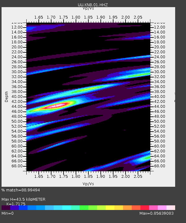
| Estimated Moho Depth: |
43.5 km |
| Estimated Crust Vp/Vs: |
1.72 |
| Assumed Crust Vp: |
6.194 km/s |
| Estimated Crust Vs: |
3.607 km/s |
| Estimated Crust Poisson's Ratio: |
0.24 |
|
| Radial Match: |
88.99494 % |
| Radial Bump: |
293 |
| Transverse Match: |
81.077194 % |
| Transverse Bump: |
358 |
| SOD ConfigId: |
2546091 |
| Insert Time: |
2018-02-04 01:14:10.742 +0000 |
| GWidth: |
2.5 |
| Max Bumps: |
400 |
| Tol: |
0.001 |
|
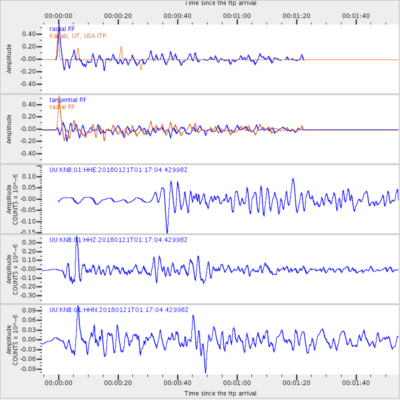
Signal To Noise
| Channel | StoN | STA | LTA |
| UU:KNB:01:HHZ:20180121T01:17:04.42998Z | 8.197335 | 6.2271354E-8 | 7.596536E-9 |
| UU:KNB:01:HHN:20180121T01:17:04.42998Z | 2.1074517 | 1.6216887E-8 | 7.695022E-9 |
| UU:KNB:01:HHE:20180121T01:17:04.42998Z | 2.2199914 | 1.966149E-8 | 8.856561E-9 |
| Arrivals |
| Ps | 5.2 SECOND |
| PpPs | 18 SECOND |
| PsPs/PpSs | 24 SECOND |


