You are here: Home > Network List > CN - Canadian National Seismograph Network Stations List
> Station DAWY Dawson, YT, CA > Earthquake Result Viewer
DAWY Dawson, YT, CA - Earthquake Result Viewer
| Earthquake location: |
Bismarck Sea |
| Earthquake latitude/longitude: |
-3.3/146.9 |
| Earthquake time(UTC): |
2021/07/21 (202) 14:26:00 GMT |
| Earthquake Depth: |
8.7 km |
| Earthquake Magnitude: |
6.0 mww |
| Earthquake Catalog/Contributor: |
NEIC PDE/us |
|
| Network: |
CN Canadian National Seismograph Network |
| Station: |
DAWY Dawson, YT, CA |
| Lat/Lon: |
64.06 N/139.39 W |
| Elevation: |
771 m |
|
| Distance: |
85.9 deg |
| Az: |
25.039 deg |
| Baz: |
253.923 deg |
| Ray Param: |
0.044421427 |
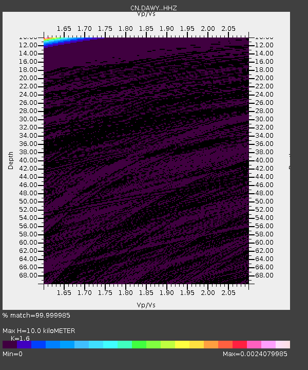
| Estimated Moho Depth: |
10.0 km |
| Estimated Crust Vp/Vs: |
1.60 |
| Assumed Crust Vp: |
6.566 km/s |
| Estimated Crust Vs: |
4.104 km/s |
| Estimated Crust Poisson's Ratio: |
0.18 |
|
| Radial Match: |
99.999985 % |
| Radial Bump: |
2 |
| Transverse Match: |
99.999985 % |
| Transverse Bump: |
2 |
| SOD ConfigId: |
25131211 |
| Insert Time: |
2021-08-04 14:31:53.297 +0000 |
| GWidth: |
2.5 |
| Max Bumps: |
400 |
| Tol: |
0.001 |
|

Signal To Noise
| Channel | StoN | STA | LTA |
| CN:DAWY: :HHZ:20210721T14:38:09.809974Z | 0.9305017 | 0.0013482149 | 0.0014489118 |
| CN:DAWY: :HHN:20210721T14:38:09.809974Z | 0.93030936 | 0.0013484498 | 0.001449464 |
| CN:DAWY: :HHE:20210721T14:38:09.809974Z | 0.9302805 | 0.0013490734 | 0.0014501791 |
| Arrivals |
| Ps | 0.9 SECOND |
| PpPs | 3.9 SECOND |
| PsPs/PpSs | 4.8 SECOND |


