You are here: Home > Network List > KZ - Kazakhstan Network Stations List
> Station ZRNK Zerenda, Kazakstan > Earthquake Result Viewer
ZRNK Zerenda, Kazakstan - Earthquake Result Viewer
| Earthquake location: |
Eastern Gulf Of Aden |
| Earthquake latitude/longitude: |
14.4/52.4 |
| Earthquake time(UTC): |
2005/08/26 (238) 18:16:33 GMT |
| Earthquake Depth: |
10 km |
| Earthquake Magnitude: |
5.7 MB, 5.9 MS, 6.2 MW, 6.2 MW |
| Earthquake Catalog/Contributor: |
WHDF/NEIC |
|
| Network: |
KZ Kazakhstan Network |
| Station: |
ZRNK Zerenda, Kazakstan |
| Lat/Lon: |
52.95 N/69.00 E |
| Elevation: |
380 m |
|
| Distance: |
40.7 deg |
| Az: |
15.424 deg |
| Baz: |
205.207 deg |
| Ray Param: |
0.074277006 |
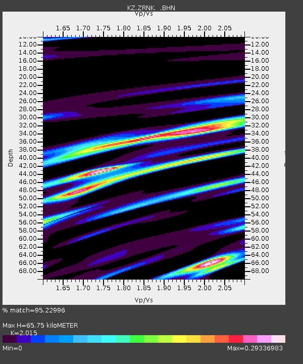
| Estimated Moho Depth: |
65.75 km |
| Estimated Crust Vp/Vs: |
2.02 |
| Assumed Crust Vp: |
6.498 km/s |
| Estimated Crust Vs: |
3.225 km/s |
| Estimated Crust Poisson's Ratio: |
0.34 |
|
| Radial Match: |
95.22996 % |
| Radial Bump: |
251 |
| Transverse Match: |
73.518295 % |
| Transverse Bump: |
400 |
| SOD ConfigId: |
2564 |
| Insert Time: |
2010-03-09 10:43:56.012 +0000 |
| GWidth: |
2.5 |
| Max Bumps: |
400 |
| Tol: |
0.001 |
|

Signal To Noise
| Channel | StoN | STA | LTA |
| KZ:ZRNK: :BHN:20050826T18:23:42.966008Z | 2.5089147 | 9.619459E-8 | 3.8341113E-8 |
| KZ:ZRNK: :BHE:20050826T18:23:42.966008Z | 1.2257779 | 6.561161E-8 | 5.3526506E-8 |
| KZ:ZRNK: :BHZ:20050826T18:23:42.966008Z | 2.313653 | 1.6418342E-7 | 7.0962855E-8 |
| Arrivals |
| Ps | 11 SECOND |
| PpPs | 29 SECOND |
| PsPs/PpSs | 40 SECOND |


