You are here: Home > Network List > KZ - Kazakhstan Network Stations List
> Station ZRNK Zerenda, Kazakstan > Earthquake Result Viewer
ZRNK Zerenda, Kazakstan - Earthquake Result Viewer
| Earthquake location: |
Mindoro, Philippines |
| Earthquake latitude/longitude: |
13.7/120.7 |
| Earthquake time(UTC): |
2000/10/21 (295) 22:30:32 GMT |
| Earthquake Depth: |
152 km |
| Earthquake Magnitude: |
5.5 MB, 5.9 MW, 5.8 MW |
| Earthquake Catalog/Contributor: |
WHDF/NEIC |
|
| Network: |
KZ Kazakhstan Network |
| Station: |
ZRNK Zerenda, Kazakstan |
| Lat/Lon: |
52.95 N/69.00 E |
| Elevation: |
380 m |
|
| Distance: |
56.5 deg |
| Az: |
325.292 deg |
| Baz: |
113.84 deg |
| Ray Param: |
0.06358904 |
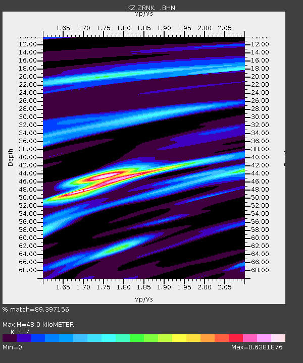
| Estimated Moho Depth: |
48.0 km |
| Estimated Crust Vp/Vs: |
1.70 |
| Assumed Crust Vp: |
6.498 km/s |
| Estimated Crust Vs: |
3.822 km/s |
| Estimated Crust Poisson's Ratio: |
0.24 |
|
| Radial Match: |
89.397156 % |
| Radial Bump: |
316 |
| Transverse Match: |
69.28988 % |
| Transverse Bump: |
400 |
| SOD ConfigId: |
3753 |
| Insert Time: |
2010-03-09 10:44:24.462 +0000 |
| GWidth: |
2.5 |
| Max Bumps: |
400 |
| Tol: |
0.001 |
|

Signal To Noise
| Channel | StoN | STA | LTA |
| KZ:ZRNK: :BHN:20001021T22:39:28.331023Z | 8.2782955 | 2.8064463E-7 | 3.390126E-8 |
| KZ:ZRNK: :BHE:20001021T22:39:28.331023Z | 11.212894 | 4.9143887E-7 | 4.382801E-8 |
| KZ:ZRNK: :BHZ:20001021T22:39:28.331023Z | 18.649548 | 1.0588006E-6 | 5.6773526E-8 |
| Arrivals |
| Ps | 5.5 SECOND |
| PpPs | 19 SECOND |
| PsPs/PpSs | 24 SECOND |


