You are here: Home > Network List > KZ - Kazakhstan Network Stations List
> Station ZRNK Zerenda, Kazakstan > Earthquake Result Viewer
ZRNK Zerenda, Kazakstan - Earthquake Result Viewer
| Earthquake location: |
Halmahera, Indonesia |
| Earthquake latitude/longitude: |
1.1/127.4 |
| Earthquake time(UTC): |
2000/09/26 (270) 16:49:33 GMT |
| Earthquake Depth: |
142 km |
| Earthquake Magnitude: |
5.8 MB, 5.9 MW, 5.8 MW |
| Earthquake Catalog/Contributor: |
WHDF/NEIC |
|
| Network: |
KZ Kazakhstan Network |
| Station: |
ZRNK Zerenda, Kazakstan |
| Lat/Lon: |
52.95 N/69.00 E |
| Elevation: |
380 m |
|
| Distance: |
70.6 deg |
| Az: |
326.866 deg |
| Baz: |
115.42 deg |
| Ray Param: |
0.05450121 |
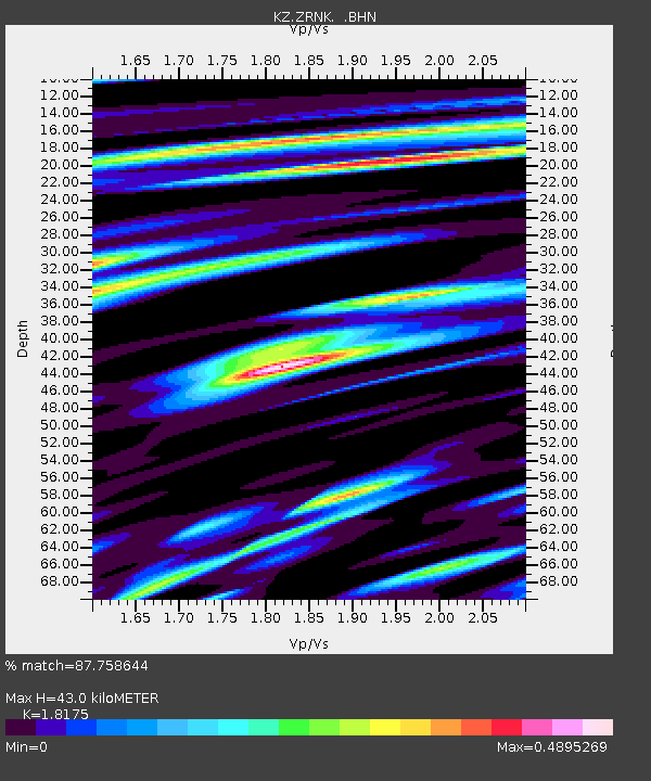
| Estimated Moho Depth: |
43.0 km |
| Estimated Crust Vp/Vs: |
1.82 |
| Assumed Crust Vp: |
6.498 km/s |
| Estimated Crust Vs: |
3.575 km/s |
| Estimated Crust Poisson's Ratio: |
0.28 |
|
| Radial Match: |
87.758644 % |
| Radial Bump: |
400 |
| Transverse Match: |
66.42979 % |
| Transverse Bump: |
400 |
| SOD ConfigId: |
3753 |
| Insert Time: |
2010-03-09 10:44:25.910 +0000 |
| GWidth: |
2.5 |
| Max Bumps: |
400 |
| Tol: |
0.001 |
|

Signal To Noise
| Channel | StoN | STA | LTA |
| KZ:ZRNK: :BHN:20000926T17:00:02.381008Z | 5.5727086 | 2.361041E-7 | 4.2367923E-8 |
| KZ:ZRNK: :BHE:20000926T17:00:02.381008Z | 8.93984 | 3.151721E-7 | 3.5254775E-8 |
| KZ:ZRNK: :BHZ:20000926T17:00:02.381008Z | 18.474432 | 9.328174E-7 | 5.0492346E-8 |
| Arrivals |
| Ps | 5.6 SECOND |
| PpPs | 18 SECOND |
| PsPs/PpSs | 24 SECOND |


