You are here: Home > Network List > CN - Canadian National Seismograph Network Stations List
> Station TXDB Texada, BC, CA > Earthquake Result Viewer
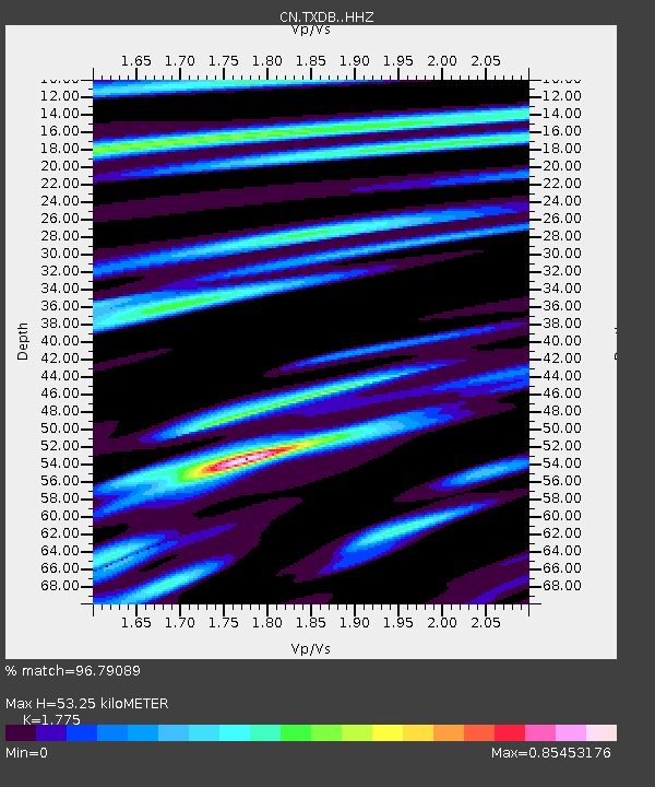
TXDB Texada, BC, CA - Earthquake Result Viewer
| Earthquake location: |
South Of Panama |
| Earthquake latitude/longitude: |
7.4/-82.8 |
| Earthquake time(UTC): |
2021/07/21 (202) 21:15:12 GMT |
| Earthquake Depth: |
10 km |
| Earthquake Magnitude: |
6.7 mww |
| Earthquake Catalog/Contributor: |
NEIC PDE/us |
|
| Network: |
CN Canadian National Seismograph Network |
| Station: |
TXDB Texada, BC, CA |
| Lat/Lon: |
49.70 N/124.44 W |
| Elevation: |
501 m |
|
| Distance: |
54.7 deg |
| Az: |
328.059 deg |
| Baz: |
126.093 deg |
| Ray Param: |
0.06530802 |
| Estimated Moho Depth: |
53.25 km |
| Estimated Crust Vp/Vs: |
1.77 |
| Assumed Crust Vp: |
6.391 km/s |
| Estimated Crust Vs: |
3.6 km/s |
| Estimated Crust Poisson's Ratio: |
0.27 |
|
| Radial Match: |
96.79089 % |
| Radial Bump: |
304 |
| Transverse Match: |
89.5959 % |
| Transverse Bump: |
400 |
| SOD ConfigId: |
25131211 |
| Insert Time: |
2021-08-04 21:25:23.096 +0000 |
| GWidth: |
2.5 |
| Max Bumps: |
400 |
| Tol: |
0.001 |
|

Signal To Noise
| Channel | StoN | STA | LTA |
| CN:TXDB: :HHZ:20210721T21:24:10.220017Z | 5.177026 | 2.8084682E-7 | 5.4248684E-8 |
| CN:TXDB: :HHN:20210721T21:24:10.220017Z | 1.5216978 | 8.8810616E-8 | 5.836285E-8 |
| CN:TXDB: :HHE:20210721T21:24:10.220017Z | 1.7980509 | 1.0230661E-7 | 5.6898617E-8 |
| Arrivals |
| Ps | 6.8 SECOND |
| PpPs | 22 SECOND |
| PsPs/PpSs | 29 SECOND |


