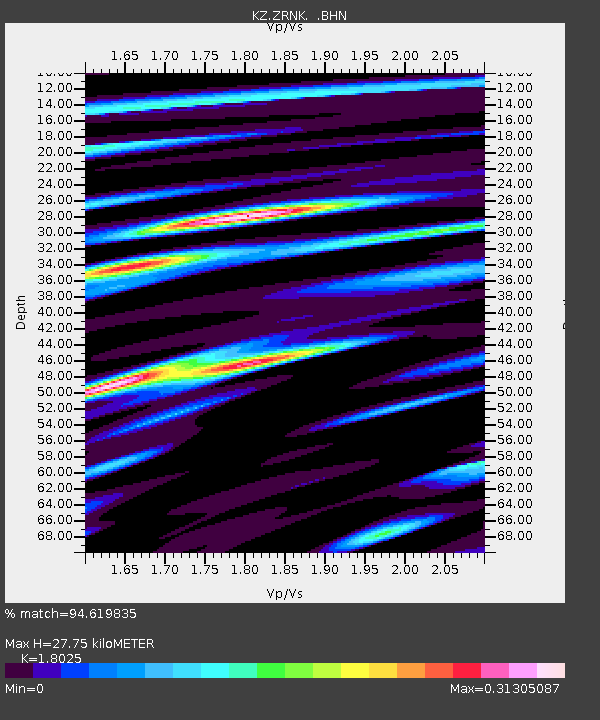
ZRNK Zerenda, Kazakstan - Earthquake Result Viewer

Earthquake location: New Ireland Region, P.N.G.
Earthquake latitude/longitude: -4.0/152.2
Earthquake time(UTC): 2000/11/16 (321) 04:54:56 GMT
Earthquake Depth: 33 km
Earthquake Magnitude: 6.0 MB, 8.2 MS, 8.0 MW, 8.0 ME
Earthquake Catalog/Contributor: WHDF/NEIC
Network: KZ Kazakhstan Network
Station: ZRNK Zerenda, Kazakstan
Lat/Lon: 52.95 N/69.00 E
Elevation: 380 m
Distance: 89.0 deg
Az: 323.068 deg
Baz: 97.832 deg
Ray Param: 0.042107336
Estimated Moho Depth: 27.75 km
Estimated Crust Vp/Vs: 1.80
Assumed Crust Vp: 6.498 km/s
Estimated Crust Vs: 3.605 km/s
Estimated Crust Poisson's Ratio: 0.28
Radial Match: 94.619835 %
Radial Bump: 261
Transverse Match: 89.827415 %
Transverse Bump: 400
SOD ConfigId: 3744
Insert Time: 2010-03-09 10:44:44.016 +0000
GWidth: 2.5
Max Bumps: 400
Tol: 0.001

Signal To Noise

ChannelStoNSTALTA
KZ:ZRNK: :BHN:20001116T05:07:17.083018Z1.4691435.394988E-83.6722003E-8
KZ:ZRNK: :BHE:20001116T05:07:17.083018Z1.46858387.029018E-84.7862557E-8
KZ:ZRNK: :BHZ:20001116T05:07:17.083018Z1.660592.2610153E-71.3615734E-7
Arrivals
Ps3.5 SECOND
PpPs12 SECOND
PsPs/PpSs15 SECOND