You are here: Home > Network List > AG - Arkansas Seismic Network Stations List
> Station WLAR White Oak Lake,AR > Earthquake Result Viewer
WLAR White Oak Lake,AR - Earthquake Result Viewer
| Earthquake location: |
Gulf Of Alaska |
| Earthquake latitude/longitude: |
56.0/-149.1 |
| Earthquake time(UTC): |
2018/01/23 (023) 09:31:42 GMT |
| Earthquake Depth: |
25 km |
| Earthquake Magnitude: |
7.9 Mww |
| Earthquake Catalog/Contributor: |
NEIC PDE/us |
|
| Network: |
AG Arkansas Seismic Network |
| Station: |
WLAR White Oak Lake,AR |
| Lat/Lon: |
33.69 N/93.11 W |
| Elevation: |
77 m |
|
| Distance: |
44.0 deg |
| Az: |
96.322 deg |
| Baz: |
318.02 deg |
| Ray Param: |
0.0721218 |
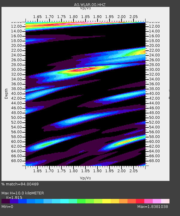
| Estimated Moho Depth: |
10.0 km |
| Estimated Crust Vp/Vs: |
1.91 |
| Assumed Crust Vp: |
6.245 km/s |
| Estimated Crust Vs: |
3.261 km/s |
| Estimated Crust Poisson's Ratio: |
0.31 |
|
| Radial Match: |
94.80469 % |
| Radial Bump: |
400 |
| Transverse Match: |
86.17265 % |
| Transverse Bump: |
400 |
| SOD ConfigId: |
2546091 |
| Insert Time: |
2018-02-06 09:31:56.900 +0000 |
| GWidth: |
2.5 |
| Max Bumps: |
400 |
| Tol: |
0.001 |
|

Signal To Noise
| Channel | StoN | STA | LTA |
| AG:WLAR:00:HHZ:20180123T09:39:17.774991Z | 14.128781 | 8.531903E-6 | 6.038669E-7 |
| AG:WLAR:00:HHN:20180123T09:39:17.774991Z | 4.9253263 | 3.575374E-6 | 7.259161E-7 |
| AG:WLAR:00:HHE:20180123T09:39:17.774991Z | 8.526715 | 3.7840489E-6 | 4.437874E-7 |
| Arrivals |
| Ps | 1.6 SECOND |
| PpPs | 4.4 SECOND |
| PsPs/PpSs | 6.0 SECOND |


