You are here: Home > Network List > N4 - Central and EAstern US Network Stations List
> Station F64A Sherman, ME, USA > Earthquake Result Viewer
F64A Sherman, ME, USA - Earthquake Result Viewer
| Earthquake location: |
South Of Panama |
| Earthquake latitude/longitude: |
7.4/-82.8 |
| Earthquake time(UTC): |
2021/07/21 (202) 21:15:12 GMT |
| Earthquake Depth: |
10 km |
| Earthquake Magnitude: |
6.7 mww |
| Earthquake Catalog/Contributor: |
NEIC PDE/us |
|
| Network: |
N4 Central and EAstern US Network |
| Station: |
F64A Sherman, ME, USA |
| Lat/Lon: |
45.86 N/68.35 W |
| Elevation: |
179 m |
|
| Distance: |
40.3 deg |
| Az: |
15.619 deg |
| Baz: |
202.466 deg |
| Ray Param: |
0.074477725 |
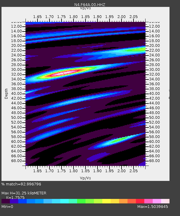
| Estimated Moho Depth: |
31.25 km |
| Estimated Crust Vp/Vs: |
1.76 |
| Assumed Crust Vp: |
6.419 km/s |
| Estimated Crust Vs: |
3.652 km/s |
| Estimated Crust Poisson's Ratio: |
0.26 |
|
| Radial Match: |
92.996796 % |
| Radial Bump: |
284 |
| Transverse Match: |
77.0187 % |
| Transverse Bump: |
400 |
| SOD ConfigId: |
25131211 |
| Insert Time: |
2021-08-04 21:29:10.437 +0000 |
| GWidth: |
2.5 |
| Max Bumps: |
400 |
| Tol: |
0.001 |
|

Signal To Noise
| Channel | StoN | STA | LTA |
| N4:F64A:00:HHZ:20210721T21:22:18.770005Z | 3.4321432 | 2.0353323E-7 | 5.930208E-8 |
| N4:F64A:00:HH1:20210721T21:22:18.770005Z | 1.509066 | 1.180779E-7 | 7.8245684E-8 |
| N4:F64A:00:HH2:20210721T21:22:18.770005Z | 1.0952307 | 7.930597E-8 | 7.241029E-8 |
| Arrivals |
| Ps | 4.0 SECOND |
| PpPs | 13 SECOND |
| PsPs/PpSs | 16 SECOND |


