You are here: Home > Network List > N4 - Central and EAstern US Network Stations List
> Station P48A Milroy, IN, USA > Earthquake Result Viewer
P48A Milroy, IN, USA - Earthquake Result Viewer
| Earthquake location: |
South Of Panama |
| Earthquake latitude/longitude: |
7.4/-82.8 |
| Earthquake time(UTC): |
2021/07/21 (202) 21:15:12 GMT |
| Earthquake Depth: |
10 km |
| Earthquake Magnitude: |
6.7 mww |
| Earthquake Catalog/Contributor: |
NEIC PDE/us |
|
| Network: |
N4 Central and EAstern US Network |
| Station: |
P48A Milroy, IN, USA |
| Lat/Lon: |
39.46 N/85.43 W |
| Elevation: |
300 m |
|
| Distance: |
32.0 deg |
| Az: |
356.138 deg |
| Baz: |
175.05 deg |
| Ray Param: |
0.07884595 |
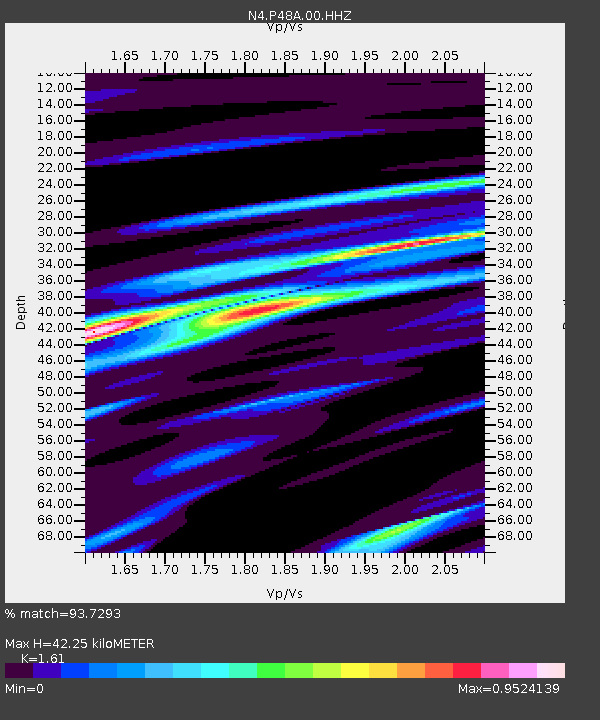
| Estimated Moho Depth: |
42.25 km |
| Estimated Crust Vp/Vs: |
1.61 |
| Assumed Crust Vp: |
6.498 km/s |
| Estimated Crust Vs: |
4.036 km/s |
| Estimated Crust Poisson's Ratio: |
0.19 |
|
| Radial Match: |
93.7293 % |
| Radial Bump: |
320 |
| Transverse Match: |
80.715294 % |
| Transverse Bump: |
400 |
| SOD ConfigId: |
25131211 |
| Insert Time: |
2021-08-04 21:30:13.368 +0000 |
| GWidth: |
2.5 |
| Max Bumps: |
400 |
| Tol: |
0.001 |
|

Signal To Noise
| Channel | StoN | STA | LTA |
| N4:P48A:00:HHZ:20210721T21:21:08.068986Z | 7.7506676 | 4.2599905E-7 | 5.4962886E-8 |
| N4:P48A:00:HH1:20210721T21:21:08.068986Z | 2.8784566 | 2.3004638E-7 | 7.992005E-8 |
| N4:P48A:00:HH2:20210721T21:21:08.068986Z | 1.0556263 | 7.580332E-8 | 7.180886E-8 |
| Arrivals |
| Ps | 4.3 SECOND |
| PpPs | 16 SECOND |
| PsPs/PpSs | 20 SECOND |


