You are here: Home > Network List > CO - South Carolina Seismic Network Stations List
> Station SUMMV Summerville Airport, SC, USA > Earthquake Result Viewer
SUMMV Summerville Airport, SC, USA - Earthquake Result Viewer
| Earthquake location: |
Gulf Of Alaska |
| Earthquake latitude/longitude: |
56.0/-149.1 |
| Earthquake time(UTC): |
2018/01/23 (023) 09:31:42 GMT |
| Earthquake Depth: |
25 km |
| Earthquake Magnitude: |
7.9 Mww |
| Earthquake Catalog/Contributor: |
NEIC PDE/us |
|
| Network: |
CO South Carolina Seismic Network |
| Station: |
SUMMV Summerville Airport, SC, USA |
| Lat/Lon: |
33.07 N/80.27 W |
| Elevation: |
17 m |
|
| Distance: |
51.7 deg |
| Az: |
86.103 deg |
| Baz: |
318.19 deg |
| Ray Param: |
0.06720735 |
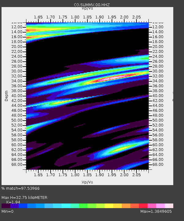
| Estimated Moho Depth: |
32.75 km |
| Estimated Crust Vp/Vs: |
1.94 |
| Assumed Crust Vp: |
6.565 km/s |
| Estimated Crust Vs: |
3.384 km/s |
| Estimated Crust Poisson's Ratio: |
0.32 |
|
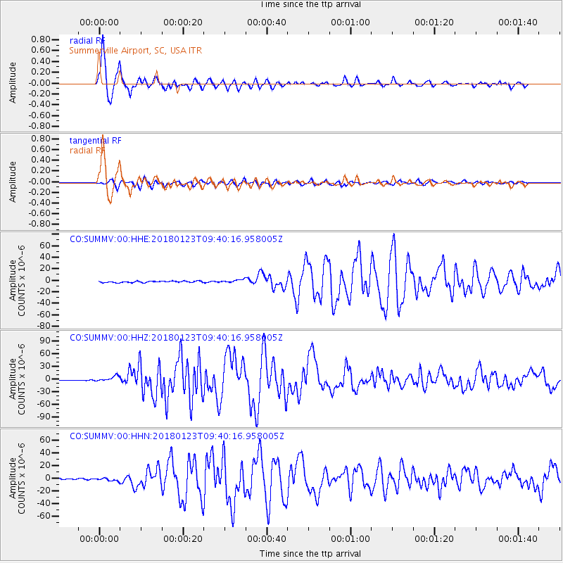
| Radial Match: |
97.53966 % |
| Radial Bump: |
376 |
| Transverse Match: |
93.25573 % |
| Transverse Bump: |
400 |
| SOD ConfigId: |
2546091 |
| Insert Time: |
2018-02-06 09:32:24.955 +0000 |
| GWidth: |
2.5 |
| Max Bumps: |
400 |
| Tol: |
0.001 |
|
Signal To Noise
| Channel | StoN | STA | LTA |
| CO:SUMMV:00:HHZ:20180123T09:40:16.958005Z | 9.214612 | 6.496554E-6 | 7.050274E-7 |
| CO:SUMMV:00:HHN:20180123T09:40:16.958005Z | 1.5267924 | 2.0334278E-6 | 1.3318298E-6 |
| CO:SUMMV:00:HHE:20180123T09:40:16.958005Z | 2.2219775 | 2.7716628E-6 | 1.2473856E-6 |
| Arrivals |
| Ps | 4.9 SECOND |
| PpPs | 14 SECOND |
| PsPs/PpSs | 19 SECOND |


