You are here: Home > Network List > CU - Caribbean Network (USGS) Stations List
> Station BCIP Isla Barro Colorado, Panama > Earthquake Result Viewer
BCIP Isla Barro Colorado, Panama - Earthquake Result Viewer
| Earthquake location: |
Gulf Of Alaska |
| Earthquake latitude/longitude: |
56.0/-149.1 |
| Earthquake time(UTC): |
2018/01/23 (023) 09:31:42 GMT |
| Earthquake Depth: |
25 km |
| Earthquake Magnitude: |
7.9 Mww |
| Earthquake Catalog/Contributor: |
NEIC PDE/us |
|
| Network: |
CU Caribbean Network (USGS) |
| Station: |
BCIP Isla Barro Colorado, Panama |
| Lat/Lon: |
9.17 N/79.84 W |
| Elevation: |
61 m |
|
| Distance: |
70.9 deg |
| Az: |
102.28 deg |
| Baz: |
326.271 deg |
| Ray Param: |
0.054653414 |
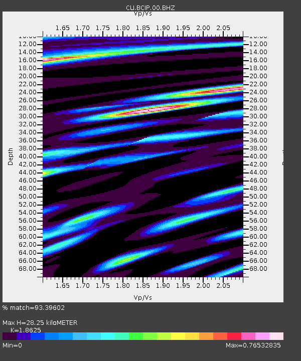
| Estimated Moho Depth: |
28.25 km |
| Estimated Crust Vp/Vs: |
1.86 |
| Assumed Crust Vp: |
6.436 km/s |
| Estimated Crust Vs: |
3.456 km/s |
| Estimated Crust Poisson's Ratio: |
0.30 |
|
| Radial Match: |
93.39602 % |
| Radial Bump: |
400 |
| Transverse Match: |
91.378975 % |
| Transverse Bump: |
400 |
| SOD ConfigId: |
2546091 |
| Insert Time: |
2018-02-06 09:32:26.911 +0000 |
| GWidth: |
2.5 |
| Max Bumps: |
400 |
| Tol: |
0.001 |
|

Signal To Noise
| Channel | StoN | STA | LTA |
| CU:BCIP:00:BHZ:20180123T09:42:26.624998Z | 9.496117 | 6.4805404E-6 | 6.824411E-7 |
| CU:BCIP:00:BH1:20180123T09:42:26.624998Z | 3.5699255 | 2.174384E-6 | 6.090839E-7 |
| CU:BCIP:00:BH2:20180123T09:42:26.624998Z | 2.9475467 | 1.5665775E-6 | 5.3148517E-7 |
| Arrivals |
| Ps | 3.9 SECOND |
| PpPs | 12 SECOND |
| PsPs/PpSs | 16 SECOND |


