You are here: Home > Network List > O2 - Oklahoma Consolidated Temporary Seismic Networks Stations List
> Station SC10 Scott, Oklahoma, USA > Earthquake Result Viewer
SC10 Scott, Oklahoma, USA - Earthquake Result Viewer
| Earthquake location: |
South Of Panama |
| Earthquake latitude/longitude: |
7.4/-82.8 |
| Earthquake time(UTC): |
2021/07/21 (202) 21:15:12 GMT |
| Earthquake Depth: |
10 km |
| Earthquake Magnitude: |
6.7 mww |
| Earthquake Catalog/Contributor: |
NEIC PDE/us |
|
| Network: |
O2 Oklahoma Consolidated Temporary Seismic Networks |
| Station: |
SC10 Scott, Oklahoma, USA |
| Lat/Lon: |
35.42 N/98.27 W |
| Elevation: |
502 m |
|
| Distance: |
31.3 deg |
| Az: |
335.185 deg |
| Baz: |
149.359 deg |
| Ray Param: |
0.079123095 |
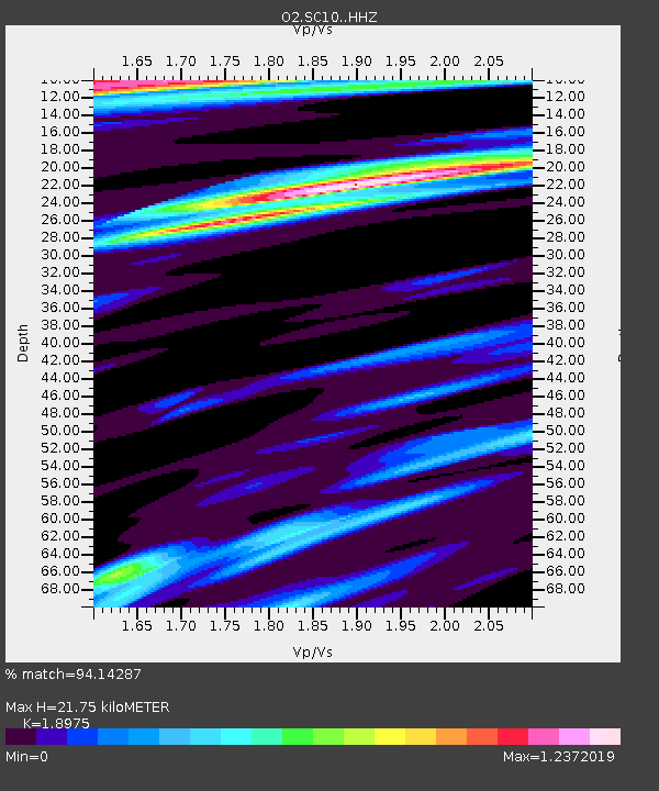
| Estimated Moho Depth: |
21.75 km |
| Estimated Crust Vp/Vs: |
1.90 |
| Assumed Crust Vp: |
6.315 km/s |
| Estimated Crust Vs: |
3.328 km/s |
| Estimated Crust Poisson's Ratio: |
0.31 |
|
| Radial Match: |
94.14287 % |
| Radial Bump: |
297 |
| Transverse Match: |
77.44381 % |
| Transverse Bump: |
400 |
| SOD ConfigId: |
25131211 |
| Insert Time: |
2021-08-04 21:32:24.579 +0000 |
| GWidth: |
2.5 |
| Max Bumps: |
400 |
| Tol: |
0.001 |
|

Signal To Noise
| Channel | StoN | STA | LTA |
| O2:SC10: :HHZ:20210721T21:21:01.870011Z | 1.9656203 | 2.6068375E-7 | 1.3262162E-7 |
| O2:SC10: :HHN:20210721T21:21:01.870011Z | 1.6016359 | 2.0177362E-7 | 1.259797E-7 |
| O2:SC10: :HHE:20210721T21:21:01.870011Z | 0.81239027 | 1.0326833E-7 | 1.2711665E-7 |
| Arrivals |
| Ps | 3.3 SECOND |
| PpPs | 9.3 SECOND |
| PsPs/PpSs | 13 SECOND |


