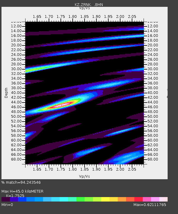
ZRNK Zerenda, Kazakstan - Earthquake Result Viewer

Earthquake location: Near S. Coast Of Honshu, Japan
Earthquake latitude/longitude: 34.3/139.3
Earthquake time(UTC): 2000/07/15 (197) 01:30:30 GMT
Earthquake Depth: 10 km
Earthquake Magnitude: 5.5 MB, 5.9 MS, 6.1 MW, 6.0 MW
Earthquake Catalog/Contributor: WHDF/NEIC
Network: KZ Kazakhstan Network
Station: ZRNK Zerenda, Kazakstan
Lat/Lon: 52.95 N/69.00 E
Elevation: 380 m
Distance: 52.0 deg
Az: 313.701 deg
Baz: 81.461 deg
Ray Param: 0.067059554
Estimated Moho Depth: 45.0 km
Estimated Crust Vp/Vs: 1.75
Assumed Crust Vp: 6.498 km/s
Estimated Crust Vs: 3.708 km/s
Estimated Crust Poisson's Ratio: 0.26
Radial Match: 94.243546 %
Radial Bump: 336
Transverse Match: 62.543976 %
Transverse Bump: 400
SOD ConfigId: 3744
Insert Time: 2010-03-09 10:45:32.947 +0000
GWidth: 2.5
Max Bumps: 400
Tol: 0.001

Signal To Noise

ChannelStoNSTALTA
KZ:ZRNK: :BHN:20000715T01:39:08.708008Z1.92940932.2227754E-71.1520497E-7
KZ:ZRNK: :BHE:20000715T01:39:08.708008Z2.27791711.15493485E-75.0701352E-8
KZ:ZRNK: :BHZ:20000715T01:39:08.708008Z3.13492.0134134E-76.422576E-8
Arrivals
Ps5.5 SECOND
PpPs18 SECOND
PsPs/PpSs24 SECOND