You are here: Home > Network List > OH - Ohio Seismic Network Stations List
> Station SSF2 Shawnee State Forest Ohio New > Earthquake Result Viewer
SSF2 Shawnee State Forest Ohio New - Earthquake Result Viewer
| Earthquake location: |
South Of Panama |
| Earthquake latitude/longitude: |
7.4/-82.8 |
| Earthquake time(UTC): |
2021/07/21 (202) 21:15:12 GMT |
| Earthquake Depth: |
10 km |
| Earthquake Magnitude: |
6.7 mww |
| Earthquake Catalog/Contributor: |
NEIC PDE/us |
|
| Network: |
OH Ohio Seismic Network |
| Station: |
SSF2 Shawnee State Forest Ohio New |
| Lat/Lon: |
38.69 N/83.13 W |
| Elevation: |
324 m |
|
| Distance: |
31.2 deg |
| Az: |
359.477 deg |
| Baz: |
179.338 deg |
| Ray Param: |
0.07917909 |
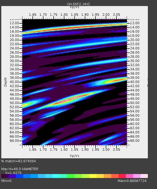
| Estimated Moho Depth: |
48.0 km |
| Estimated Crust Vp/Vs: |
1.83 |
| Assumed Crust Vp: |
6.232 km/s |
| Estimated Crust Vs: |
3.41 km/s |
| Estimated Crust Poisson's Ratio: |
0.29 |
|
| Radial Match: |
92.874054 % |
| Radial Bump: |
354 |
| Transverse Match: |
68.85839 % |
| Transverse Bump: |
400 |
| SOD ConfigId: |
25131211 |
| Insert Time: |
2021-08-04 21:32:54.892 +0000 |
| GWidth: |
2.5 |
| Max Bumps: |
400 |
| Tol: |
0.001 |
|

Signal To Noise
| Channel | StoN | STA | LTA |
| OH:SSF2: :HHZ:20210721T21:21:00.539994Z | 0.99750334 | 2.512392E-7 | 2.5186802E-7 |
| OH:SSF2: :HHN:20210721T21:21:00.539994Z | 2.6493492 | 8.658212E-7 | 3.2680524E-7 |
| OH:SSF2: :HHE:20210721T21:21:00.539994Z | 1.2103059 | 4.4744598E-7 | 3.6969658E-7 |
| Arrivals |
| Ps | 6.9 SECOND |
| PpPs | 20 SECOND |
| PsPs/PpSs | 27 SECOND |


