You are here: Home > Network List > KZ - Kazakhstan Network Stations List
> Station ZRNK Zerenda, Kazakstan > Earthquake Result Viewer
ZRNK Zerenda, Kazakstan - Earthquake Result Viewer
| Earthquake location: |
Sea Of Okhotsk |
| Earthquake latitude/longitude: |
46.8/145.4 |
| Earthquake time(UTC): |
2000/07/10 (192) 09:58:18 GMT |
| Earthquake Depth: |
360 km |
| Earthquake Magnitude: |
6.1 MB, 5.9 MW, 5.8 MW |
| Earthquake Catalog/Contributor: |
WHDF/NEIC |
|
| Network: |
KZ Kazakhstan Network |
| Station: |
ZRNK Zerenda, Kazakstan |
| Lat/Lon: |
52.95 N/69.00 E |
| Elevation: |
380 m |
|
| Distance: |
47.4 deg |
| Az: |
307.01 deg |
| Baz: |
64.98 deg |
| Ray Param: |
0.06850287 |
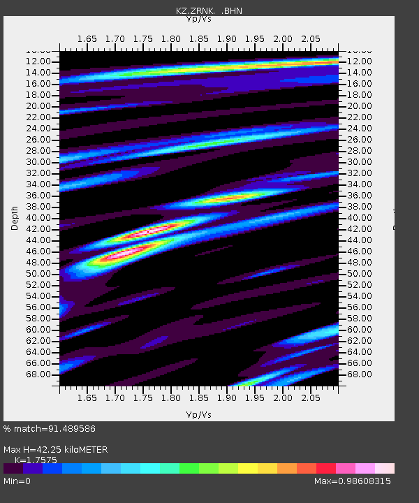
| Estimated Moho Depth: |
42.25 km |
| Estimated Crust Vp/Vs: |
1.76 |
| Assumed Crust Vp: |
6.498 km/s |
| Estimated Crust Vs: |
3.697 km/s |
| Estimated Crust Poisson's Ratio: |
0.26 |
|
| Radial Match: |
91.489586 % |
| Radial Bump: |
400 |
| Transverse Match: |
83.19077 % |
| Transverse Bump: |
400 |
| SOD ConfigId: |
3744 |
| Insert Time: |
2010-03-09 10:45:34.382 +0000 |
| GWidth: |
2.5 |
| Max Bumps: |
400 |
| Tol: |
0.001 |
|

Signal To Noise
| Channel | StoN | STA | LTA |
| KZ:ZRNK: :BHN:20000710T10:05:48.20701Z | 21.199057 | 8.2220157E-7 | 3.878482E-8 |
| KZ:ZRNK: :BHE:20000710T10:05:48.20701Z | 41.71956 | 1.3686132E-6 | 3.2805076E-8 |
| KZ:ZRNK: :BHZ:20000710T10:05:48.20701Z | 52.776283 | 2.965392E-6 | 5.6187965E-8 |
| Arrivals |
| Ps | 5.2 SECOND |
| PpPs | 17 SECOND |
| PsPs/PpSs | 22 SECOND |


