You are here: Home > Network List > CW - Servicio Sismologico Nacional de Cuba (SSNC) Stations List
> Station NMDO Presa Nuevo Mundo, Moa, Holguin > Earthquake Result Viewer
NMDO Presa Nuevo Mundo, Moa, Holguin - Earthquake Result Viewer
| Earthquake location: |
Gulf Of Alaska |
| Earthquake latitude/longitude: |
56.0/-149.1 |
| Earthquake time(UTC): |
2018/01/23 (023) 09:31:42 GMT |
| Earthquake Depth: |
25 km |
| Earthquake Magnitude: |
7.9 Mww |
| Earthquake Catalog/Contributor: |
NEIC PDE/us |
|
| Network: |
CW Servicio Sismologico Nacional de Cuba (SSNC) |
| Station: |
NMDO Presa Nuevo Mundo, Moa, Holguin |
| Lat/Lon: |
20.56 N/74.98 W |
| Elevation: |
50 m |
|
| Distance: |
64.3 deg |
| Az: |
91.064 deg |
| Baz: |
323.225 deg |
| Ray Param: |
0.058955155 |
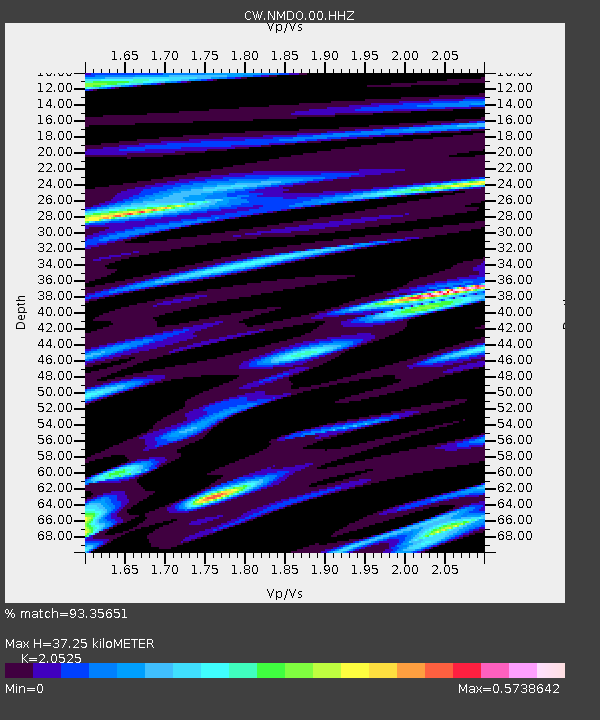
| Estimated Moho Depth: |
37.25 km |
| Estimated Crust Vp/Vs: |
2.05 |
| Assumed Crust Vp: |
5.066 km/s |
| Estimated Crust Vs: |
2.468 km/s |
| Estimated Crust Poisson's Ratio: |
0.34 |
|
| Radial Match: |
93.35651 % |
| Radial Bump: |
380 |
| Transverse Match: |
81.827095 % |
| Transverse Bump: |
400 |
| SOD ConfigId: |
2546091 |
| Insert Time: |
2018-02-06 09:32:47.124 +0000 |
| GWidth: |
2.5 |
| Max Bumps: |
400 |
| Tol: |
0.001 |
|
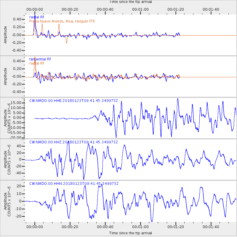
Signal To Noise
| Channel | StoN | STA | LTA |
| CW:NMDO:00:HHZ:20180123T09:41:45.349973Z | 14.442468 | 5.388677E-6 | 3.7311332E-7 |
| CW:NMDO:00:HHN:20180123T09:41:45.349973Z | 7.596918 | 2.2633676E-6 | 2.9793236E-7 |
| CW:NMDO:00:HHE:20180123T09:41:45.349973Z | 5.057254 | 1.3549409E-6 | 2.6792029E-7 |
| Arrivals |
| Ps | 7.9 SECOND |
| PpPs | 22 SECOND |
| PsPs/PpSs | 30 SECOND |


