You are here: Home > Network List > US - United States National Seismic Network Stations List
> Station ACSO Alum Creek State Park, Ohio, USA > Earthquake Result Viewer
ACSO Alum Creek State Park, Ohio, USA - Earthquake Result Viewer
| Earthquake location: |
South Of Panama |
| Earthquake latitude/longitude: |
7.4/-82.8 |
| Earthquake time(UTC): |
2021/07/21 (202) 21:15:12 GMT |
| Earthquake Depth: |
10 km |
| Earthquake Magnitude: |
6.7 mww |
| Earthquake Catalog/Contributor: |
NEIC PDE/us |
|
| Network: |
US United States National Seismic Network |
| Station: |
ACSO Alum Creek State Park, Ohio, USA |
| Lat/Lon: |
40.23 N/82.98 W |
| Elevation: |
288 m |
|
| Distance: |
32.7 deg |
| Az: |
359.717 deg |
| Baz: |
179.633 deg |
| Ray Param: |
0.0785472 |
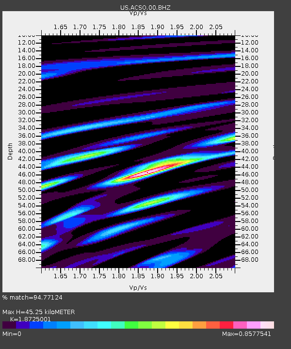
| Estimated Moho Depth: |
45.25 km |
| Estimated Crust Vp/Vs: |
1.87 |
| Assumed Crust Vp: |
6.498 km/s |
| Estimated Crust Vs: |
3.47 km/s |
| Estimated Crust Poisson's Ratio: |
0.30 |
|
| Radial Match: |
94.77124 % |
| Radial Bump: |
296 |
| Transverse Match: |
91.13237 % |
| Transverse Bump: |
400 |
| SOD ConfigId: |
25131211 |
| Insert Time: |
2021-08-04 21:37:24.533 +0000 |
| GWidth: |
2.5 |
| Max Bumps: |
400 |
| Tol: |
0.001 |
|
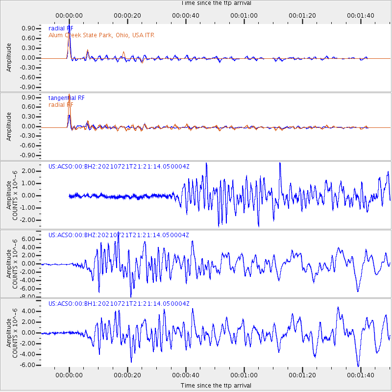
Signal To Noise
| Channel | StoN | STA | LTA |
| US:ACSO:00:BHZ:20210721T21:21:14.050004Z | 4.852905 | 3.0659575E-7 | 6.317779E-8 |
| US:ACSO:00:BH1:20210721T21:21:14.050004Z | 2.3520644 | 2.1211964E-7 | 9.018446E-8 |
| US:ACSO:00:BH2:20210721T21:21:14.050004Z | 1.0185637 | 8.871576E-8 | 8.7098876E-8 |
| Arrivals |
| Ps | 6.6 SECOND |
| PpPs | 19 SECOND |
| PsPs/PpSs | 25 SECOND |


