You are here: Home > Network List > US - United States National Seismic Network Stations List
> Station BW06 Boulder Array Site 6 (Pinedale), Wyoming, USA > Earthquake Result Viewer
BW06 Boulder Array Site 6 (Pinedale), Wyoming, USA - Earthquake Result Viewer

| Earthquake location: |
South Of Panama |
| Earthquake latitude/longitude: |
7.4/-82.8 |
| Earthquake time(UTC): |
2021/07/21 (202) 21:15:12 GMT |
| Earthquake Depth: |
10 km |
| Earthquake Magnitude: |
6.7 mww |
| Earthquake Catalog/Contributor: |
NEIC PDE/us |
|
| Network: |
US United States National Seismic Network |
| Station: |
BW06 Boulder Array Site 6 (Pinedale), Wyoming, USA |
| Lat/Lon: |
42.77 N/109.56 W |
| Elevation: |
2224 m |
|
| Distance: |
42.4 deg |
| Az: |
330.527 deg |
| Baz: |
138.496 deg |
| Ray Param: |
0.07320733 |
| Estimated Moho Depth: |
25.0 km |
| Estimated Crust Vp/Vs: |
2.10 |
| Assumed Crust Vp: |
6.161 km/s |
| Estimated Crust Vs: |
2.937 km/s |
| Estimated Crust Poisson's Ratio: |
0.35 |
|
| Radial Match: |
96.74936 % |
| Radial Bump: |
400 |
| Transverse Match: |
89.42944 % |
| Transverse Bump: |
400 |
| SOD ConfigId: |
25131211 |
| Insert Time: |
2021-08-04 21:37:33.143 +0000 |
| GWidth: |
2.5 |
| Max Bumps: |
400 |
| Tol: |
0.001 |
|
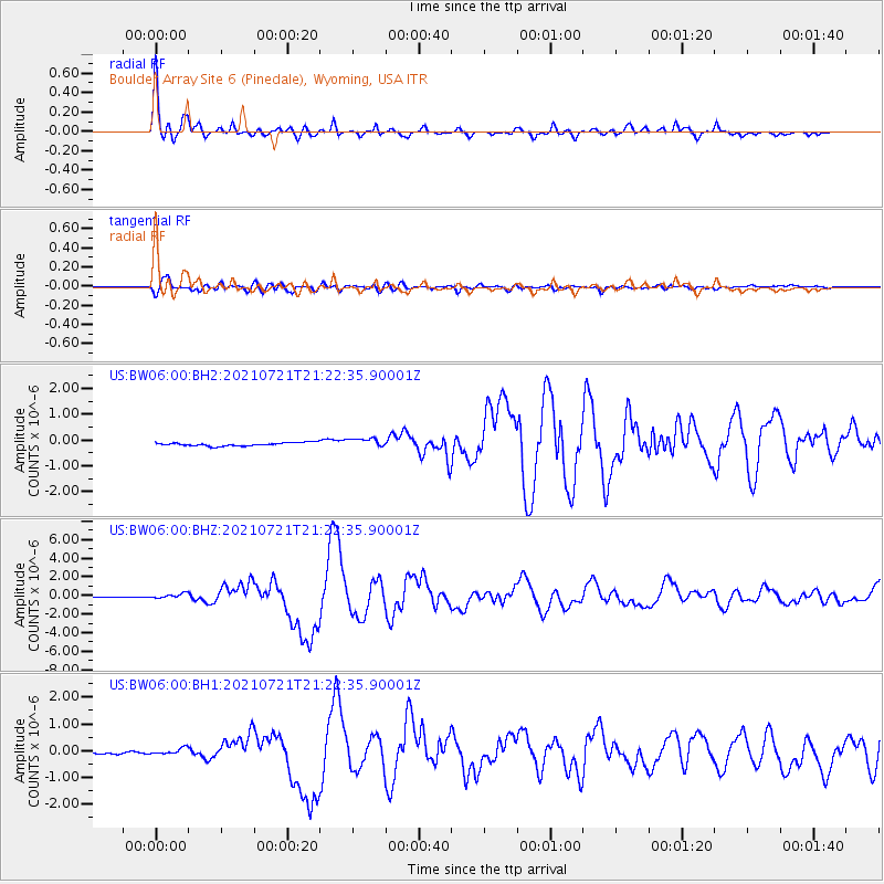
Signal To Noise
| Channel | StoN | STA | LTA |
| US:BW06:00:BHZ:20210721T21:22:35.90001Z | 3.75877 | 2.4136094E-7 | 6.421275E-8 |
| US:BW06:00:BH1:20210721T21:22:35.90001Z | 2.2480452 | 1.055116E-7 | 4.6934822E-8 |
| US:BW06:00:BH2:20210721T21:22:35.90001Z | 2.9986348 | 1.9151342E-7 | 6.386687E-8 |
| Arrivals |
| Ps | 4.7 SECOND |
| PpPs | 12 SECOND |
| PsPs/PpSs | 17 SECOND |


