You are here: Home > Network List > G - GEOSCOPE Stations List
> Station DZM Dzumac, New Caledonia > Earthquake Result Viewer
DZM Dzumac, New Caledonia - Earthquake Result Viewer
| Earthquake location: |
Gulf Of Alaska |
| Earthquake latitude/longitude: |
56.0/-149.1 |
| Earthquake time(UTC): |
2018/01/23 (023) 09:31:42 GMT |
| Earthquake Depth: |
25 km |
| Earthquake Magnitude: |
7.9 Mww |
| Earthquake Catalog/Contributor: |
NEIC PDE/us |
|
| Network: |
G GEOSCOPE |
| Station: |
DZM Dzumac, New Caledonia |
| Lat/Lon: |
22.07 S/166.44 E |
| Elevation: |
878 m |
|
| Distance: |
86.4 deg |
| Az: |
220.634 deg |
| Baz: |
23.199 deg |
| Ray Param: |
0.044023752 |
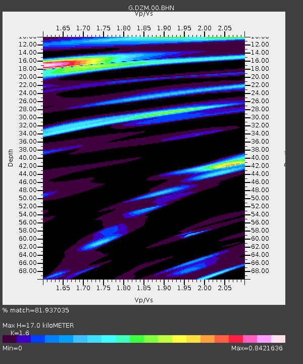
| Estimated Moho Depth: |
17.0 km |
| Estimated Crust Vp/Vs: |
1.60 |
| Assumed Crust Vp: |
5.14 km/s |
| Estimated Crust Vs: |
3.212 km/s |
| Estimated Crust Poisson's Ratio: |
0.18 |
|
| Radial Match: |
81.937035 % |
| Radial Bump: |
400 |
| Transverse Match: |
84.59425 % |
| Transverse Bump: |
400 |
| SOD ConfigId: |
2546091 |
| Insert Time: |
2018-02-06 09:33:02.823 +0000 |
| GWidth: |
2.5 |
| Max Bumps: |
400 |
| Tol: |
0.001 |
|
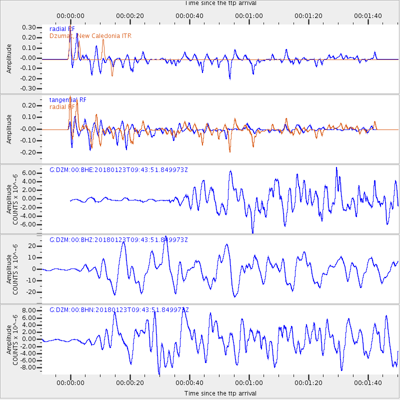
Signal To Noise
| Channel | StoN | STA | LTA |
| G:DZM:00:BHZ:20180123T09:43:51.849973Z | 2.6830003 | 1.4344774E-6 | 5.346542E-7 |
| G:DZM:00:BHN:20180123T09:43:51.849973Z | 1.4947338 | 5.084139E-7 | 3.4013675E-7 |
| G:DZM:00:BHE:20180123T09:43:51.849973Z | 0.5897287 | 1.7447327E-7 | 2.9585345E-7 |
| Arrivals |
| Ps | 2.0 SECOND |
| PpPs | 8.5 SECOND |
| PsPs/PpSs | 10 SECOND |


