You are here: Home > Network List > UW - Pacific Northwest Regional Seismic Network Stations List
> Station IRON Crane, OR, USA > Earthquake Result Viewer
IRON Crane, OR, USA - Earthquake Result Viewer
| Earthquake location: |
South Of Panama |
| Earthquake latitude/longitude: |
7.4/-82.8 |
| Earthquake time(UTC): |
2021/07/21 (202) 21:15:12 GMT |
| Earthquake Depth: |
10 km |
| Earthquake Magnitude: |
6.7 mww |
| Earthquake Catalog/Contributor: |
NEIC PDE/us |
|
| Network: |
UW Pacific Northwest Regional Seismic Network |
| Station: |
IRON Crane, OR, USA |
| Lat/Lon: |
43.36 N/118.47 W |
| Elevation: |
1226 m |
|
| Distance: |
47.6 deg |
| Az: |
324.781 deg |
| Baz: |
128.353 deg |
| Ray Param: |
0.069921516 |
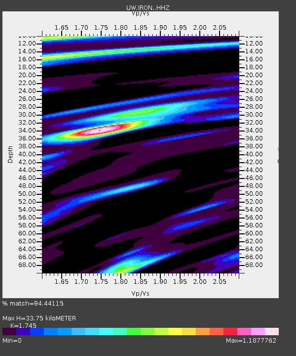
| Estimated Moho Depth: |
33.75 km |
| Estimated Crust Vp/Vs: |
1.75 |
| Assumed Crust Vp: |
6.279 km/s |
| Estimated Crust Vs: |
3.598 km/s |
| Estimated Crust Poisson's Ratio: |
0.26 |
|
| Radial Match: |
94.44115 % |
| Radial Bump: |
400 |
| Transverse Match: |
85.748405 % |
| Transverse Bump: |
400 |
| SOD ConfigId: |
25131211 |
| Insert Time: |
2021-08-04 21:39:18.231 +0000 |
| GWidth: |
2.5 |
| Max Bumps: |
400 |
| Tol: |
0.001 |
|

Signal To Noise
| Channel | StoN | STA | LTA |
| UW:IRON: :HHZ:20210721T21:23:16.857987Z | 5.2872047 | 2.6049347E-7 | 4.9268657E-8 |
| UW:IRON: :HHN:20210721T21:23:16.857987Z | 1.6678005 | 5.0610286E-8 | 3.0345525E-8 |
| UW:IRON: :HHE:20210721T21:23:16.857987Z | 1.8117892 | 9.433917E-8 | 5.206962E-8 |
| Arrivals |
| Ps | 4.2 SECOND |
| PpPs | 14 SECOND |
| PsPs/PpSs | 18 SECOND |


