You are here: Home > Network List > G - GEOSCOPE Stations List
> Station FUTU Maopo'opo, Futuna > Earthquake Result Viewer
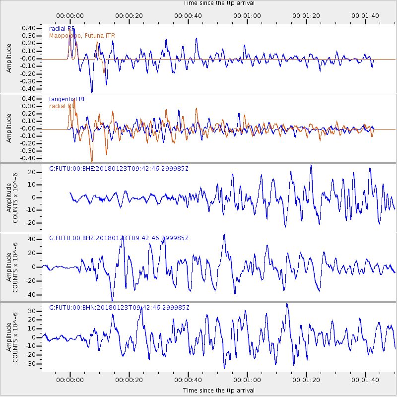
FUTU Maopo'opo, Futuna - Earthquake Result Viewer
*The percent match for this event was below the threshold and hence no stack was calculated.
| Earthquake location: |
Gulf Of Alaska |
| Earthquake latitude/longitude: |
56.0/-149.1 |
| Earthquake time(UTC): |
2018/01/23 (023) 09:31:42 GMT |
| Earthquake Depth: |
25 km |
| Earthquake Magnitude: |
7.9 Mww |
| Earthquake Catalog/Contributor: |
NEIC PDE/us |
|
| Network: |
G GEOSCOPE |
| Station: |
FUTU Maopo'opo, Futuna |
| Lat/Lon: |
14.31 S/178.12 W |
| Elevation: |
97 m |
|
| Distance: |
74.2 deg |
| Az: |
209.285 deg |
| Baz: |
16.447 deg |
| Ray Param: |
$rayparam |
*The percent match for this event was below the threshold and hence was not used in the summary stack. |
|
| Radial Match: |
88.477135 % |
| Radial Bump: |
400 |
| Transverse Match: |
73.766785 % |
| Transverse Bump: |
400 |
| SOD ConfigId: |
2546091 |
| Insert Time: |
2018-02-06 09:33:07.678 +0000 |
| GWidth: |
2.5 |
| Max Bumps: |
400 |
| Tol: |
0.001 |
|
Signal To Noise
| Channel | StoN | STA | LTA |
| G:FUTU:00:BHZ:20180123T09:42:46.299985Z | 2.3211353 | 4.3189107E-6 | 1.8606889E-6 |
| G:FUTU:00:BHN:20180123T09:42:46.299985Z | 0.7193695 | 2.0930931E-6 | 2.909622E-6 |
| G:FUTU:00:BHE:20180123T09:42:46.299985Z | 0.89479744 | 2.1452527E-6 | 2.397473E-6 |
| Arrivals |
| Ps | |
| PpPs | |
| PsPs/PpSs | |


