You are here: Home > Network List > UW - Pacific Northwest Regional Seismic Network Stations List
> Station NEMA NEMA Site, Pacific County, WA, USA > Earthquake Result Viewer
NEMA NEMA Site, Pacific County, WA, USA - Earthquake Result Viewer
| Earthquake location: |
South Of Panama |
| Earthquake latitude/longitude: |
7.4/-82.8 |
| Earthquake time(UTC): |
2021/07/21 (202) 21:15:12 GMT |
| Earthquake Depth: |
10 km |
| Earthquake Magnitude: |
6.7 mww |
| Earthquake Catalog/Contributor: |
NEIC PDE/us |
|
| Network: |
UW Pacific Northwest Regional Seismic Network |
| Station: |
NEMA NEMA Site, Pacific County, WA, USA |
| Lat/Lon: |
46.50 N/123.75 W |
| Elevation: |
509 m |
|
| Distance: |
52.4 deg |
| Az: |
325.15 deg |
| Baz: |
124.874 deg |
| Ray Param: |
0.06675539 |
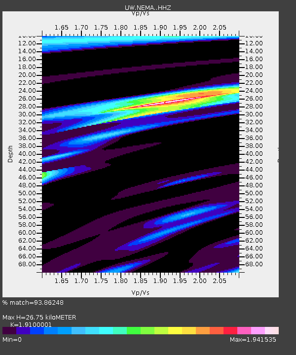
| Estimated Moho Depth: |
26.75 km |
| Estimated Crust Vp/Vs: |
1.91 |
| Assumed Crust Vp: |
6.566 km/s |
| Estimated Crust Vs: |
3.438 km/s |
| Estimated Crust Poisson's Ratio: |
0.31 |
|
| Radial Match: |
93.86248 % |
| Radial Bump: |
275 |
| Transverse Match: |
85.894516 % |
| Transverse Bump: |
400 |
| SOD ConfigId: |
25131211 |
| Insert Time: |
2021-08-04 21:39:40.894 +0000 |
| GWidth: |
2.5 |
| Max Bumps: |
400 |
| Tol: |
0.001 |
|

Signal To Noise
| Channel | StoN | STA | LTA |
| UW:NEMA: :HHZ:20210721T21:23:53.850022Z | 3.2158277 | 2.6185353E-7 | 8.142648E-8 |
| UW:NEMA: :HHN:20210721T21:23:53.850022Z | 1.625556 | 1.1049494E-7 | 6.797363E-8 |
| UW:NEMA: :HHE:20210721T21:23:53.850022Z | 1.7574977 | 1.4076427E-7 | 8.009358E-8 |
| Arrivals |
| Ps | 3.9 SECOND |
| PpPs | 11 SECOND |
| PsPs/PpSs | 15 SECOND |


