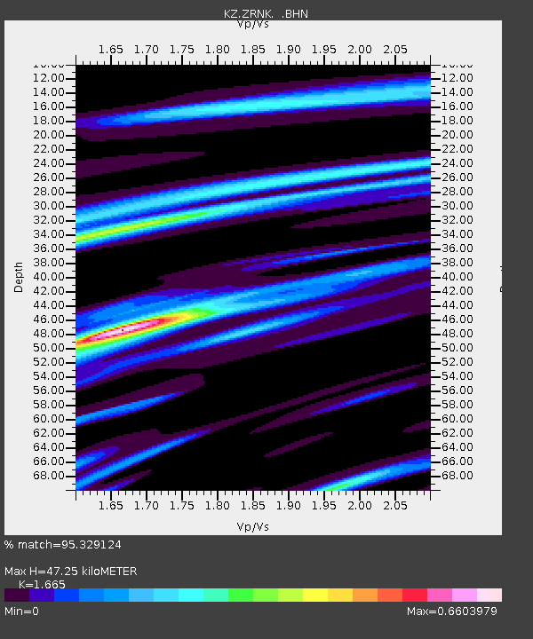
ZRNK Zerenda, Kazakstan - Earthquake Result Viewer

Earthquake location: Andaman Islands, India Region
Earthquake latitude/longitude: 12.2/93.4
Earthquake time(UTC): 2001/08/05 (217) 05:16:16 GMT
Earthquake Depth: 96 km
Earthquake Magnitude: 5.4 MB, 5.2 MS, 6.0 MW, 5.9 MW
Earthquake Catalog/Contributor: WHDF/NEIC
Network: KZ Kazakhstan Network
Station: ZRNK Zerenda, Kazakstan
Lat/Lon: 52.95 N/69.00 E
Elevation: 380 m
Distance: 45.1 deg
Az: 339.363 deg
Baz: 145.289 deg
Ray Param: 0.07119524
Estimated Moho Depth: 47.25 km
Estimated Crust Vp/Vs: 1.66
Assumed Crust Vp: 6.498 km/s
Estimated Crust Vs: 3.902 km/s
Estimated Crust Poisson's Ratio: 0.22
Radial Match: 95.329124 %
Radial Bump: 254
Transverse Match: 83.627525 %
Transverse Bump: 400
SOD ConfigId: 20082
Insert Time: 2010-03-09 10:46:36.904 +0000
GWidth: 2.5
Max Bumps: 400
Tol: 0.001

Signal To Noise

ChannelStoNSTALTA
KZ:ZRNK: :BHN:20010805T05:23:52.655015Z7.2407892.3280157E-73.215141E-8
KZ:ZRNK: :BHE:20010805T05:23:52.655015Z9.0576051.5058336E-71.6625076E-8
KZ:ZRNK: :BHZ:20010805T05:23:52.655015Z12.0706984.2336046E-73.5073402E-8
Arrivals
Ps5.2 SECOND
PpPs18 SECOND
PsPs/PpSs23 SECOND