You are here: Home > Network List > UW - Pacific Northwest Regional Seismic Network Stations List
> Station UMAT Pilot Rock, OR, USA > Earthquake Result Viewer
UMAT Pilot Rock, OR, USA - Earthquake Result Viewer
| Earthquake location: |
South Of Panama |
| Earthquake latitude/longitude: |
7.4/-82.8 |
| Earthquake time(UTC): |
2021/07/21 (202) 21:15:12 GMT |
| Earthquake Depth: |
10 km |
| Earthquake Magnitude: |
6.7 mww |
| Earthquake Catalog/Contributor: |
NEIC PDE/us |
|
| Network: |
UW Pacific Northwest Regional Seismic Network |
| Station: |
UMAT Pilot Rock, OR, USA |
| Lat/Lon: |
45.29 N/118.96 W |
| Elevation: |
1318 m |
|
| Distance: |
49.0 deg |
| Az: |
326.507 deg |
| Baz: |
129.164 deg |
| Ray Param: |
0.06896901 |
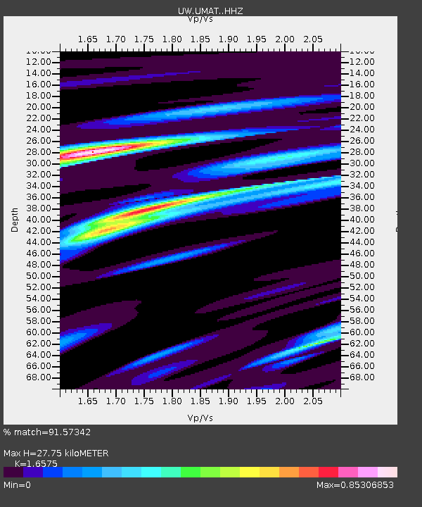
| Estimated Moho Depth: |
27.75 km |
| Estimated Crust Vp/Vs: |
1.66 |
| Assumed Crust Vp: |
6.571 km/s |
| Estimated Crust Vs: |
3.964 km/s |
| Estimated Crust Poisson's Ratio: |
0.21 |
|
| Radial Match: |
91.57342 % |
| Radial Bump: |
235 |
| Transverse Match: |
86.16828 % |
| Transverse Bump: |
344 |
| SOD ConfigId: |
25131211 |
| Insert Time: |
2021-08-04 21:40:08.695 +0000 |
| GWidth: |
2.5 |
| Max Bumps: |
400 |
| Tol: |
0.001 |
|

Signal To Noise
| Channel | StoN | STA | LTA |
| UW:UMAT: :HHZ:20210721T21:23:28.270005Z | 4.16037 | 2.5015203E-7 | 6.0127356E-8 |
| UW:UMAT: :HHN:20210721T21:23:28.270005Z | 2.8661666 | 9.355711E-8 | 3.2641896E-8 |
| UW:UMAT: :HHE:20210721T21:23:28.270005Z | 3.915947 | 1.3657454E-7 | 3.4876503E-8 |
| Arrivals |
| Ps | 3.0 SECOND |
| PpPs | 10 SECOND |
| PsPs/PpSs | 13 SECOND |


