You are here: Home > Network List > KZ - Kazakhstan Network Stations List
> Station ZRNK Zerenda, Kazakstan > Earthquake Result Viewer
ZRNK Zerenda, Kazakstan - Earthquake Result Viewer
| Earthquake location: |
Kuril Islands |
| Earthquake latitude/longitude: |
43.9/147.8 |
| Earthquake time(UTC): |
2001/01/03 (003) 14:47:49 GMT |
| Earthquake Depth: |
33 km |
| Earthquake Magnitude: |
5.9 MB, 5.2 MS, 5.9 MW, 5.9 MW |
| Earthquake Catalog/Contributor: |
WHDF/NEIC |
|
| Network: |
KZ Kazakhstan Network |
| Station: |
ZRNK Zerenda, Kazakstan |
| Lat/Lon: |
52.95 N/69.00 E |
| Elevation: |
380 m |
|
| Distance: |
50.6 deg |
| Az: |
309.771 deg |
| Baz: |
66.6 deg |
| Ray Param: |
0.0679112 |
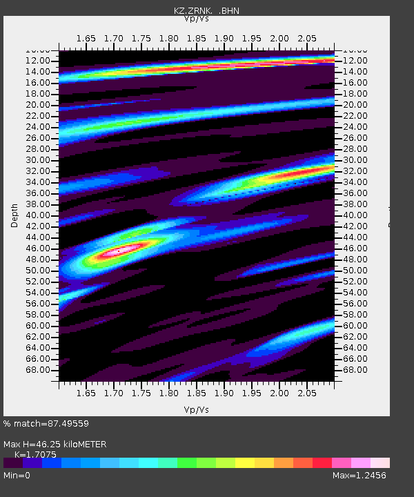
| Estimated Moho Depth: |
46.25 km |
| Estimated Crust Vp/Vs: |
1.71 |
| Assumed Crust Vp: |
6.498 km/s |
| Estimated Crust Vs: |
3.805 km/s |
| Estimated Crust Poisson's Ratio: |
0.24 |
|
| Radial Match: |
87.49559 % |
| Radial Bump: |
359 |
| Transverse Match: |
69.63028 % |
| Transverse Bump: |
400 |
| SOD ConfigId: |
3753 |
| Insert Time: |
2010-03-09 10:46:41.800 +0000 |
| GWidth: |
2.5 |
| Max Bumps: |
400 |
| Tol: |
0.001 |
|

Signal To Noise
| Channel | StoN | STA | LTA |
| KZ:ZRNK: :BHN:20010103T14:56:14.227012Z | 3.348994 | 2.5370213E-7 | 7.575472E-8 |
| KZ:ZRNK: :BHE:20010103T14:56:14.227012Z | 8.268377 | 6.6291057E-7 | 8.01742E-8 |
| KZ:ZRNK: :BHZ:20010103T14:56:14.227012Z | 14.3445635 | 1.3300026E-6 | 9.271823E-8 |
| Arrivals |
| Ps | 5.4 SECOND |
| PpPs | 18 SECOND |
| PsPs/PpSs | 23 SECOND |


