You are here: Home > Network List > G - GEOSCOPE Stations List
> Station NOUC Port Laguerre, New Caledonia > Earthquake Result Viewer
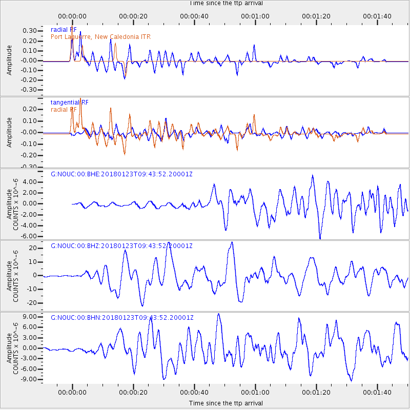
NOUC Port Laguerre, New Caledonia - Earthquake Result Viewer
*The percent match for this event was below the threshold and hence no stack was calculated.
| Earthquake location: |
Gulf Of Alaska |
| Earthquake latitude/longitude: |
56.0/-149.1 |
| Earthquake time(UTC): |
2018/01/23 (023) 09:31:42 GMT |
| Earthquake Depth: |
25 km |
| Earthquake Magnitude: |
7.9 Mww |
| Earthquake Catalog/Contributor: |
NEIC PDE/us |
|
| Network: |
G GEOSCOPE |
| Station: |
NOUC Port Laguerre, New Caledonia |
| Lat/Lon: |
22.10 S/166.30 E |
| Elevation: |
112 m |
|
| Distance: |
86.5 deg |
| Az: |
220.742 deg |
| Baz: |
23.258 deg |
| Ray Param: |
$rayparam |
*The percent match for this event was below the threshold and hence was not used in the summary stack. |
|
| Radial Match: |
88.05441 % |
| Radial Bump: |
400 |
| Transverse Match: |
77.97158 % |
| Transverse Bump: |
400 |
| SOD ConfigId: |
2546091 |
| Insert Time: |
2018-02-06 09:33:13.001 +0000 |
| GWidth: |
2.5 |
| Max Bumps: |
400 |
| Tol: |
0.001 |
|
Signal To Noise
| Channel | StoN | STA | LTA |
| G:NOUC:00:BHZ:20180123T09:43:52.20001Z | 4.652472 | 1.5205777E-6 | 3.2683224E-7 |
| G:NOUC:00:BHN:20180123T09:43:52.20001Z | 3.3272235 | 4.919884E-7 | 1.4786754E-7 |
| G:NOUC:00:BHE:20180123T09:43:52.20001Z | 1.0908602 | 3.4895493E-7 | 3.198897E-7 |
| Arrivals |
| Ps | |
| PpPs | |
| PsPs/PpSs | |


