You are here: Home > Network List > WY - Yellowstone Wyoming Seismic Network Stations List
> Station YPP Pitchstone Plateau, YNP, WY, USA > Earthquake Result Viewer
YPP Pitchstone Plateau, YNP, WY, USA - Earthquake Result Viewer
| Earthquake location: |
South Of Panama |
| Earthquake latitude/longitude: |
7.4/-82.8 |
| Earthquake time(UTC): |
2021/07/21 (202) 21:15:12 GMT |
| Earthquake Depth: |
10 km |
| Earthquake Magnitude: |
6.7 mww |
| Earthquake Catalog/Contributor: |
NEIC PDE/us |
|
| Network: |
WY Yellowstone Wyoming Seismic Network |
| Station: |
YPP Pitchstone Plateau, YNP, WY, USA |
| Lat/Lon: |
44.27 N/110.80 W |
| Elevation: |
2707 m |
|
| Distance: |
44.1 deg |
| Az: |
331.001 deg |
| Baz: |
137.987 deg |
| Ray Param: |
0.07212531 |
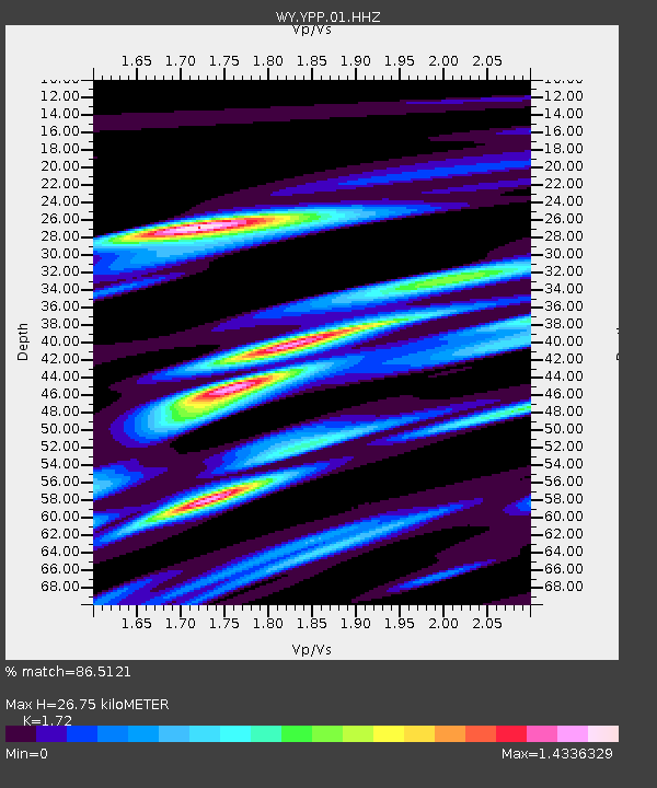
| Estimated Moho Depth: |
26.75 km |
| Estimated Crust Vp/Vs: |
1.72 |
| Assumed Crust Vp: |
6.35 km/s |
| Estimated Crust Vs: |
3.692 km/s |
| Estimated Crust Poisson's Ratio: |
0.24 |
|
| Radial Match: |
86.5121 % |
| Radial Bump: |
400 |
| Transverse Match: |
82.74607 % |
| Transverse Bump: |
400 |
| SOD ConfigId: |
25131211 |
| Insert Time: |
2021-08-04 21:41:02.764 +0000 |
| GWidth: |
2.5 |
| Max Bumps: |
400 |
| Tol: |
0.001 |
|

Signal To Noise
| Channel | StoN | STA | LTA |
| WY:YPP:01:HHZ:20210721T21:22:49.827988Z | 2.838129 | 3.6952321E-9 | 1.3019958E-9 |
| WY:YPP:01:HHN:20210721T21:22:49.827988Z | 0.9652545 | 1.815328E-8 | 1.8806729E-8 |
| WY:YPP:01:HHE:20210721T21:22:49.827988Z | 0.94642293 | 1.0908103E-8 | 1.1525612E-8 |
| Arrivals |
| Ps | 3.2 SECOND |
| PpPs | 11 SECOND |
| PsPs/PpSs | 14 SECOND |


