You are here: Home > Network List > KZ - Kazakhstan Network Stations List
> Station ZRNK Zerenda, Kazakstan > Earthquake Result Viewer
ZRNK Zerenda, Kazakstan - Earthquake Result Viewer
| Earthquake location: |
Minahassa Peninsula, Sulawesi |
| Earthquake latitude/longitude: |
0.5/121.9 |
| Earthquake time(UTC): |
2001/03/14 (073) 18:56:18 GMT |
| Earthquake Depth: |
109 km |
| Earthquake Magnitude: |
5.9 MB, 6.0 MW, 5.9 MW |
| Earthquake Catalog/Contributor: |
WHDF/NEIC |
|
| Network: |
KZ Kazakhstan Network |
| Station: |
ZRNK Zerenda, Kazakstan |
| Lat/Lon: |
52.95 N/69.00 E |
| Elevation: |
380 m |
|
| Distance: |
68.2 deg |
| Az: |
328.69 deg |
| Baz: |
120.815 deg |
| Ray Param: |
0.056174077 |
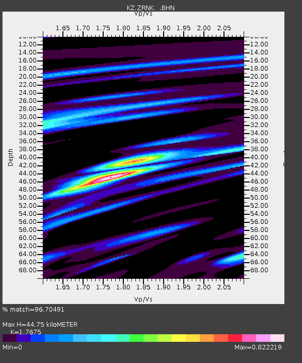
| Estimated Moho Depth: |
44.75 km |
| Estimated Crust Vp/Vs: |
1.77 |
| Assumed Crust Vp: |
6.498 km/s |
| Estimated Crust Vs: |
3.676 km/s |
| Estimated Crust Poisson's Ratio: |
0.26 |
|
| Radial Match: |
96.70491 % |
| Radial Bump: |
330 |
| Transverse Match: |
86.439995 % |
| Transverse Bump: |
400 |
| SOD ConfigId: |
3744 |
| Insert Time: |
2010-03-09 10:47:05.046 +0000 |
| GWidth: |
2.5 |
| Max Bumps: |
400 |
| Tol: |
0.001 |
|

Signal To Noise
| Channel | StoN | STA | LTA |
| KZ:ZRNK: :BHN:20010314T19:06:36.77801Z | 12.078163 | 5.2179644E-7 | 4.3201638E-8 |
| KZ:ZRNK: :BHE:20010314T19:06:36.77801Z | 23.178455 | 6.329022E-7 | 2.7305623E-8 |
| KZ:ZRNK: :BHZ:20010314T19:06:36.77801Z | 39.694725 | 1.8887577E-6 | 4.758208E-8 |
| Arrivals |
| Ps | 5.5 SECOND |
| PpPs | 18 SECOND |
| PsPs/PpSs | 24 SECOND |


