You are here: Home > Network List > GM - US Geological Survey Networks Stations List
> Station IWM01 Jericho 2M Well Monitoring Station > Earthquake Result Viewer
IWM01 Jericho 2M Well Monitoring Station - Earthquake Result Viewer
| Earthquake location: |
Gulf Of Alaska |
| Earthquake latitude/longitude: |
56.0/-149.1 |
| Earthquake time(UTC): |
2018/01/23 (023) 09:31:42 GMT |
| Earthquake Depth: |
25 km |
| Earthquake Magnitude: |
7.9 Mww |
| Earthquake Catalog/Contributor: |
NEIC PDE/us |
|
| Network: |
GM US Geological Survey Networks |
| Station: |
IWM01 Jericho 2M Well Monitoring Station |
| Lat/Lon: |
36.73 N/96.53 W |
| Elevation: |
328 m |
|
| Distance: |
39.9 deg |
| Az: |
96.296 deg |
| Baz: |
316.038 deg |
| Ray Param: |
0.07466226 |
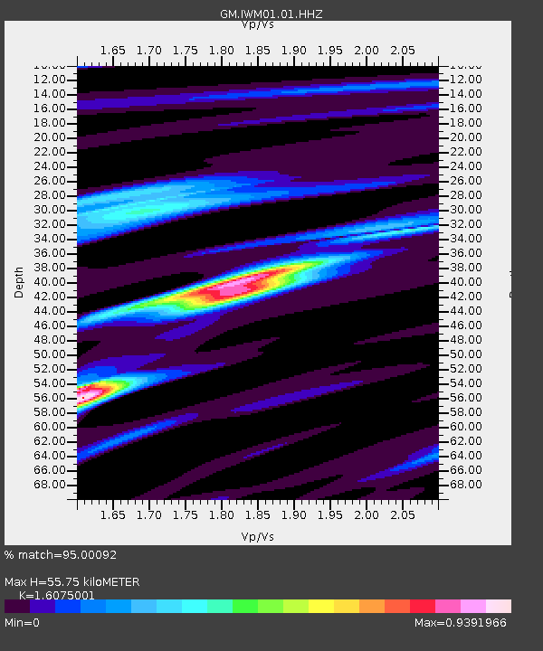
| Estimated Moho Depth: |
55.75 km |
| Estimated Crust Vp/Vs: |
1.61 |
| Assumed Crust Vp: |
6.483 km/s |
| Estimated Crust Vs: |
4.033 km/s |
| Estimated Crust Poisson's Ratio: |
0.18 |
|
| Radial Match: |
95.00092 % |
| Radial Bump: |
201 |
| Transverse Match: |
83.94297 % |
| Transverse Bump: |
400 |
| SOD ConfigId: |
2546091 |
| Insert Time: |
2018-02-06 09:33:31.652 +0000 |
| GWidth: |
2.5 |
| Max Bumps: |
400 |
| Tol: |
0.001 |
|

Signal To Noise
| Channel | StoN | STA | LTA |
| GM:IWM01:01:HHZ:20180123T09:38:44.140012Z | 11.527876 | 8.240195E-6 | 7.1480594E-7 |
| GM:IWM01:01:HHN:20180123T09:38:44.140012Z | 3.1907449 | 2.4052688E-6 | 7.538267E-7 |
| GM:IWM01:01:HHE:20180123T09:38:44.140012Z | 8.787107 | 4.377295E-6 | 4.981498E-7 |
| Arrivals |
| Ps | 5.7 SECOND |
| PpPs | 21 SECOND |
| PsPs/PpSs | 26 SECOND |


