You are here: Home > Network List > GS - US Geological Survey Networks Stations List
> Station DEC10 Finch Street Surface Site > Earthquake Result Viewer
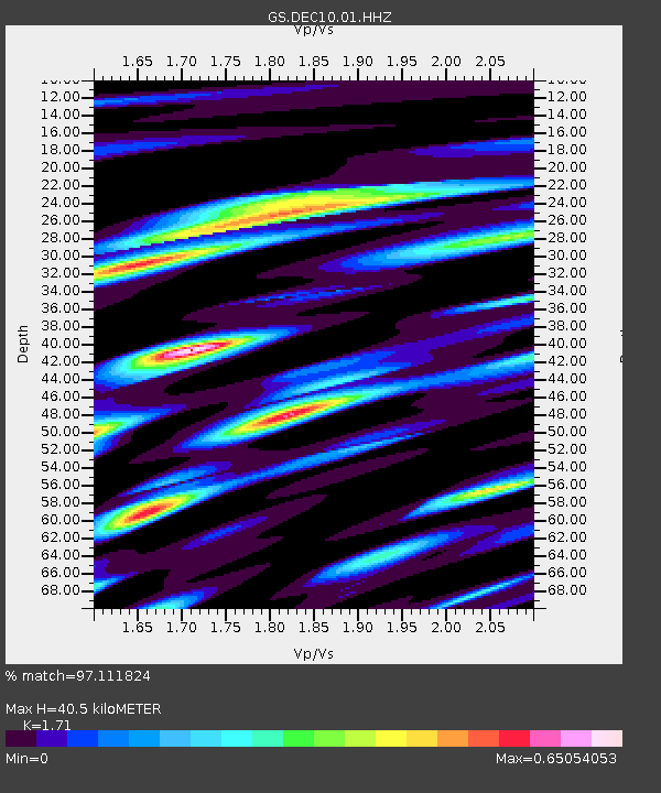
DEC10 Finch Street Surface Site - Earthquake Result Viewer
| Earthquake location: |
Gulf Of Alaska |
| Earthquake latitude/longitude: |
56.0/-149.1 |
| Earthquake time(UTC): |
2018/01/23 (023) 09:31:42 GMT |
| Earthquake Depth: |
25 km |
| Earthquake Magnitude: |
7.9 Mww |
| Earthquake Catalog/Contributor: |
NEIC PDE/us |
|
| Network: |
GS US Geological Survey Networks |
| Station: |
DEC10 Finch Street Surface Site |
| Lat/Lon: |
39.89 N/88.92 W |
| Elevation: |
210 m |
|
| Distance: |
42.0 deg |
| Az: |
86.442 deg |
| Baz: |
313.291 deg |
| Ray Param: |
0.07341608 |
| Estimated Moho Depth: |
40.5 km |
| Estimated Crust Vp/Vs: |
1.71 |
| Assumed Crust Vp: |
6.444 km/s |
| Estimated Crust Vs: |
3.768 km/s |
| Estimated Crust Poisson's Ratio: |
0.24 |
|
| Radial Match: |
97.111824 % |
| Radial Bump: |
355 |
| Transverse Match: |
79.12716 % |
| Transverse Bump: |
400 |
| SOD ConfigId: |
2546091 |
| Insert Time: |
2018-02-06 09:33:44.901 +0000 |
| GWidth: |
2.5 |
| Max Bumps: |
400 |
| Tol: |
0.001 |
|

Signal To Noise
| Channel | StoN | STA | LTA |
| GS:DEC10:01:HHZ:20180123T09:39:00.993986Z | 7.7623596 | 5.209822E-6 | 6.7116474E-7 |
| GS:DEC10:01:HHN:20180123T09:39:00.993986Z | 1.7797707 | 2.6447997E-6 | 1.4860339E-6 |
| GS:DEC10:01:HHE:20180123T09:39:00.993986Z | 1.5986006 | 1.6459167E-6 | 1.0295984E-6 |
| Arrivals |
| Ps | 4.8 SECOND |
| PpPs | 16 SECOND |
| PsPs/PpSs | 21 SECOND |


