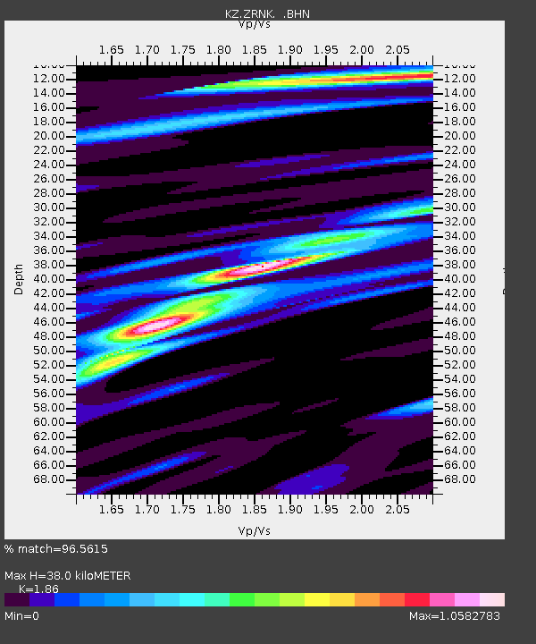
ZRNK Zerenda, Kazakstan - Earthquake Result Viewer

Earthquake location: Kodiak Island Region, Alaska
Earthquake latitude/longitude: 57.2/-151.0
Earthquake time(UTC): 2001/07/19 (200) 18:00:40 GMT
Earthquake Depth: 33 km
Earthquake Magnitude: 5.9 MB, 5.4 MS, 5.9 MW, 5.9 ML
Earthquake Catalog/Contributor: WHDF/NEIC
Network: KZ Kazakhstan Network
Station: ZRNK Zerenda, Kazakstan
Lat/Lon: 52.95 N/69.00 E
Elevation: 380 m
Distance: 65.4 deg
Az: 334.658 deg
Baz: 22.643 deg
Ray Param: 0.058224753
Estimated Moho Depth: 38.0 km
Estimated Crust Vp/Vs: 1.86
Assumed Crust Vp: 6.498 km/s
Estimated Crust Vs: 3.493 km/s
Estimated Crust Poisson's Ratio: 0.30
Radial Match: 96.5615 %
Radial Bump: 370
Transverse Match: 84.7674 %
Transverse Bump: 400
SOD ConfigId: 3753
Insert Time: 2010-03-09 10:47:49.579 +0000
GWidth: 2.5
Max Bumps: 400
Tol: 0.001

Signal To Noise

ChannelStoNSTALTA
KZ:ZRNK: :BHN:20010719T18:10:49.054011Z20.4342826.3766834E-73.120581E-8
KZ:ZRNK: :BHE:20010719T18:10:49.054011Z14.8225362.898669E-71.9555824E-8
KZ:ZRNK: :BHZ:20010719T18:10:49.054011Z45.885121.7031358E-63.711739E-8
Arrivals
Ps5.2 SECOND
PpPs16 SECOND
PsPs/PpSs21 SECOND