You are here: Home > Network List > GS - US Geological Survey Networks Stations List
> Station KAN08 Anthony NE Station > Earthquake Result Viewer
KAN08 Anthony NE Station - Earthquake Result Viewer
| Earthquake location: |
Gulf Of Alaska |
| Earthquake latitude/longitude: |
56.0/-149.1 |
| Earthquake time(UTC): |
2018/01/23 (023) 09:31:42 GMT |
| Earthquake Depth: |
25 km |
| Earthquake Magnitude: |
7.9 Mww |
| Earthquake Catalog/Contributor: |
NEIC PDE/us |
|
| Network: |
GS US Geological Survey Networks |
| Station: |
KAN08 Anthony NE Station |
| Lat/Lon: |
37.23 N/97.97 W |
| Elevation: |
375 m |
|
| Distance: |
38.8 deg |
| Az: |
97.055 deg |
| Baz: |
315.762 deg |
| Ray Param: |
0.075340524 |
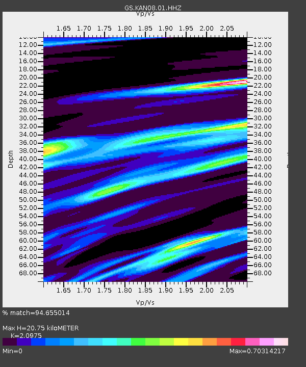
| Estimated Moho Depth: |
20.75 km |
| Estimated Crust Vp/Vs: |
2.10 |
| Assumed Crust Vp: |
6.483 km/s |
| Estimated Crust Vs: |
3.091 km/s |
| Estimated Crust Poisson's Ratio: |
0.35 |
|
| Radial Match: |
94.655014 % |
| Radial Bump: |
272 |
| Transverse Match: |
37.634235 % |
| Transverse Bump: |
400 |
| SOD ConfigId: |
2546091 |
| Insert Time: |
2018-02-06 09:33:51.537 +0000 |
| GWidth: |
2.5 |
| Max Bumps: |
400 |
| Tol: |
0.001 |
|
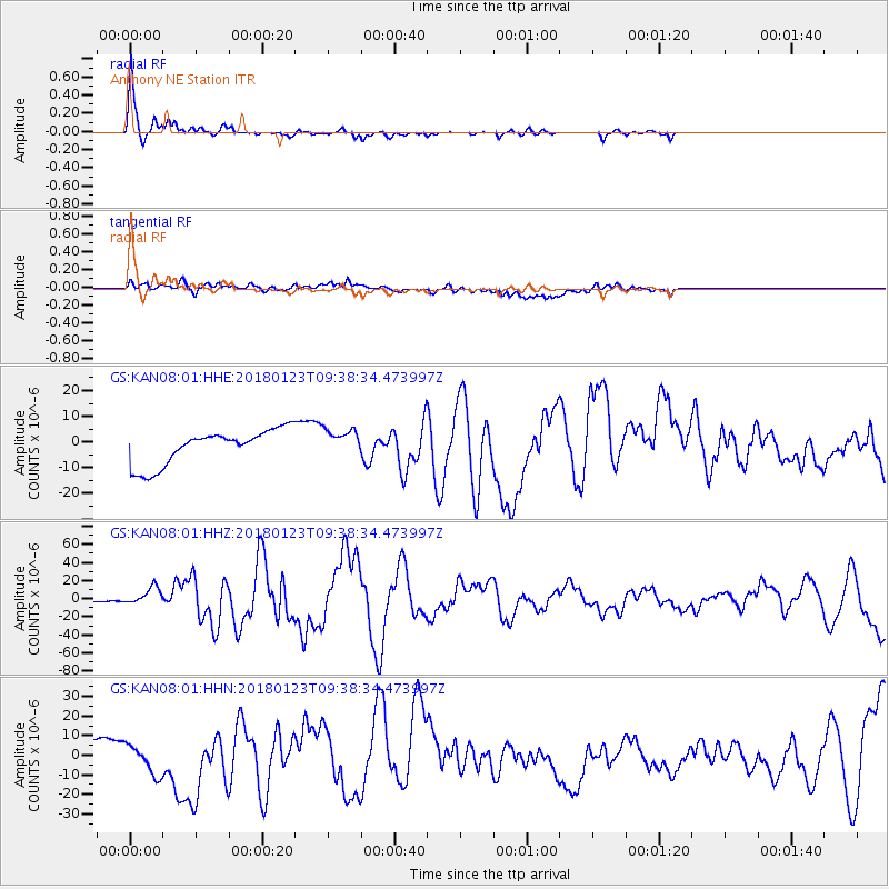
Signal To Noise
| Channel | StoN | STA | LTA |
| GS:KAN08:01:HHZ:20180123T09:38:34.473997Z | 13.276863 | 9.639481E-6 | 7.2603603E-7 |
| GS:KAN08:01:HHN:20180123T09:38:34.473997Z | 1.1264569 | 7.3159413E-6 | 6.4946485E-6 |
| GS:KAN08:01:HHE:20180123T09:38:34.473997Z | 0.80957866 | 5.5239957E-6 | 6.823297E-6 |
| Arrivals |
| Ps | 3.7 SECOND |
| PpPs | 9.3 SECOND |
| PsPs/PpSs | 13 SECOND |


