You are here: Home > Network List > GS - US Geological Survey Networks Stations List
> Station KAN09 Caldwell North Station > Earthquake Result Viewer
KAN09 Caldwell North Station - Earthquake Result Viewer
| Earthquake location: |
Gulf Of Alaska |
| Earthquake latitude/longitude: |
56.0/-149.1 |
| Earthquake time(UTC): |
2018/01/23 (023) 09:31:42 GMT |
| Earthquake Depth: |
25 km |
| Earthquake Magnitude: |
7.9 Mww |
| Earthquake Catalog/Contributor: |
NEIC PDE/us |
|
| Network: |
GS US Geological Survey Networks |
| Station: |
KAN09 Caldwell North Station |
| Lat/Lon: |
37.14 N/97.62 W |
| Elevation: |
371 m |
|
| Distance: |
39.0 deg |
| Az: |
96.834 deg |
| Baz: |
315.802 deg |
| Ray Param: |
0.07518974 |
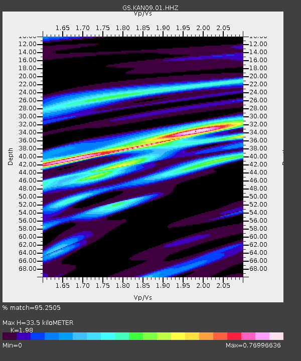
| Estimated Moho Depth: |
33.5 km |
| Estimated Crust Vp/Vs: |
1.98 |
| Assumed Crust Vp: |
6.483 km/s |
| Estimated Crust Vs: |
3.274 km/s |
| Estimated Crust Poisson's Ratio: |
0.33 |
|
| Radial Match: |
95.2505 % |
| Radial Bump: |
229 |
| Transverse Match: |
81.68474 % |
| Transverse Bump: |
400 |
| SOD ConfigId: |
2546091 |
| Insert Time: |
2018-02-06 09:33:54.178 +0000 |
| GWidth: |
2.5 |
| Max Bumps: |
400 |
| Tol: |
0.001 |
|

Signal To Noise
| Channel | StoN | STA | LTA |
| GS:KAN09:01:HHZ:20180123T09:38:36.658994Z | 14.343125 | 9.142279E-6 | 6.37398E-7 |
| GS:KAN09:01:HHN:20180123T09:38:36.658994Z | 9.641782 | 4.566711E-6 | 4.7363767E-7 |
| GS:KAN09:01:HHE:20180123T09:38:36.658994Z | 2.1431038 | 2.9827272E-6 | 1.3917792E-6 |
| Arrivals |
| Ps | 5.4 SECOND |
| PpPs | 14 SECOND |
| PsPs/PpSs | 20 SECOND |


