You are here: Home > Network List > KZ - Kazakhstan Network Stations List
> Station ZRNK Zerenda, Kazakstan > Earthquake Result Viewer
ZRNK Zerenda, Kazakstan - Earthquake Result Viewer
| Earthquake location: |
Halmahera, Indonesia |
| Earthquake latitude/longitude: |
1.8/127.2 |
| Earthquake time(UTC): |
2002/05/26 (146) 00:10:21 GMT |
| Earthquake Depth: |
109 km |
| Earthquake Magnitude: |
5.8 MB, 5.9 MW, 5.8 MW |
| Earthquake Catalog/Contributor: |
WHDF/NEIC |
|
| Network: |
KZ Kazakhstan Network |
| Station: |
ZRNK Zerenda, Kazakstan |
| Lat/Lon: |
52.95 N/69.00 E |
| Elevation: |
380 m |
|
| Distance: |
69.9 deg |
| Az: |
326.784 deg |
| Baz: |
115.192 deg |
| Ray Param: |
0.055061568 |
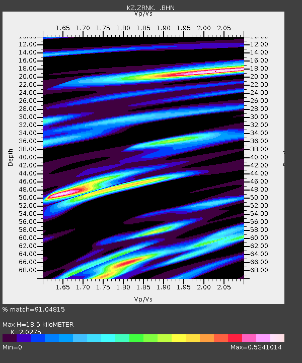
| Estimated Moho Depth: |
18.5 km |
| Estimated Crust Vp/Vs: |
2.03 |
| Assumed Crust Vp: |
6.498 km/s |
| Estimated Crust Vs: |
3.205 km/s |
| Estimated Crust Poisson's Ratio: |
0.34 |
|
| Radial Match: |
91.04815 % |
| Radial Bump: |
400 |
| Transverse Match: |
74.06203 % |
| Transverse Bump: |
400 |
| SOD ConfigId: |
20082 |
| Insert Time: |
2010-03-09 10:48:11.607 +0000 |
| GWidth: |
2.5 |
| Max Bumps: |
400 |
| Tol: |
0.001 |
|

Signal To Noise
| Channel | StoN | STA | LTA |
| KZ:ZRNK: :BHN:20020526T00:20:49.417014Z | 4.1716824 | 2.2724458E-7 | 5.447313E-8 |
| KZ:ZRNK: :BHE:20020526T00:20:49.417014Z | 7.640908 | 3.6559436E-7 | 4.784698E-8 |
| KZ:ZRNK: :BHZ:20020526T00:20:49.417014Z | 11.058238 | 9.3830073E-7 | 8.485083E-8 |
| Arrivals |
| Ps | 3.0 SECOND |
| PpPs | 8.3 SECOND |
| PsPs/PpSs | 11 SECOND |


