You are here: Home > Network List > HK - Hong Kong Seismographic Network Stations List
> Station HKPS Po Shan, Hong Kong > Earthquake Result Viewer
HKPS Po Shan, Hong Kong - Earthquake Result Viewer
| Earthquake location: |
Gulf Of Alaska |
| Earthquake latitude/longitude: |
56.0/-149.1 |
| Earthquake time(UTC): |
2018/01/23 (023) 09:31:42 GMT |
| Earthquake Depth: |
25 km |
| Earthquake Magnitude: |
7.9 Mww |
| Earthquake Catalog/Contributor: |
NEIC PDE/us |
|
| Network: |
HK Hong Kong Seismographic Network |
| Station: |
HKPS Po Shan, Hong Kong |
| Lat/Lon: |
22.28 N/114.14 E |
| Elevation: |
196 m |
|
| Distance: |
75.5 deg |
| Az: |
288.182 deg |
| Baz: |
35.137 deg |
| Ray Param: |
0.051605362 |
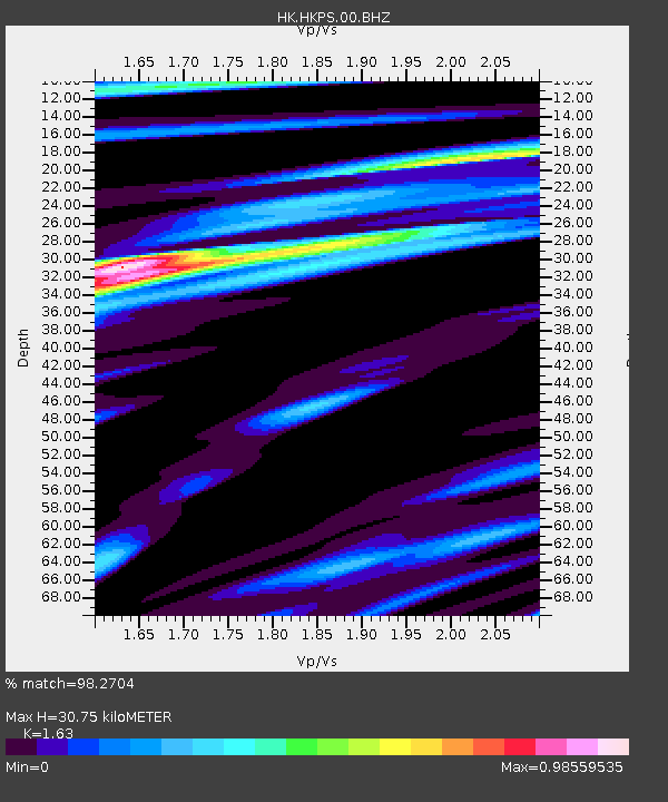
| Estimated Moho Depth: |
30.75 km |
| Estimated Crust Vp/Vs: |
1.63 |
| Assumed Crust Vp: |
6.472 km/s |
| Estimated Crust Vs: |
3.97 km/s |
| Estimated Crust Poisson's Ratio: |
0.20 |
|
| Radial Match: |
98.2704 % |
| Radial Bump: |
314 |
| Transverse Match: |
94.94334 % |
| Transverse Bump: |
400 |
| SOD ConfigId: |
2546091 |
| Insert Time: |
2018-02-06 09:34:13.983 +0000 |
| GWidth: |
2.5 |
| Max Bumps: |
400 |
| Tol: |
0.001 |
|
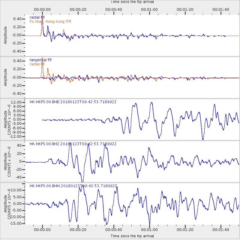
Signal To Noise
| Channel | StoN | STA | LTA |
| HK:HKPS:00:BHZ:20180123T09:42:53.718992Z | 8.260219 | 3.7635314E-6 | 4.556213E-7 |
| HK:HKPS:00:BHN:20180123T09:42:53.718992Z | 2.8196144 | 1.2077015E-6 | 4.283215E-7 |
| HK:HKPS:00:BHE:20180123T09:42:53.718992Z | 3.4904327 | 8.680382E-7 | 2.4869072E-7 |
| Arrivals |
| Ps | 3.1 SECOND |
| PpPs | 12 SECOND |
| PsPs/PpSs | 15 SECOND |


