You are here: Home > Network List > KZ - Kazakhstan Network Stations List
> Station ZRNK Zerenda, Kazakstan > Earthquake Result Viewer
ZRNK Zerenda, Kazakstan - Earthquake Result Viewer
| Earthquake location: |
Hokkaido, Japan Region |
| Earthquake latitude/longitude: |
41.2/142.2 |
| Earthquake time(UTC): |
2002/10/14 (287) 14:12:43 GMT |
| Earthquake Depth: |
61 km |
| Earthquake Magnitude: |
5.9 MB, 6.1 MW, 6.1 MW |
| Earthquake Catalog/Contributor: |
WHDF/NEIC |
|
| Network: |
KZ Kazakhstan Network |
| Station: |
ZRNK Zerenda, Kazakstan |
| Lat/Lon: |
52.95 N/69.00 E |
| Elevation: |
380 m |
|
| Distance: |
49.2 deg |
| Az: |
310.027 deg |
| Baz: |
72.814 deg |
| Ray Param: |
0.06870174 |
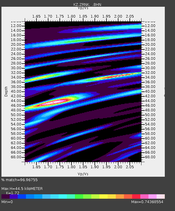
| Estimated Moho Depth: |
44.5 km |
| Estimated Crust Vp/Vs: |
1.72 |
| Assumed Crust Vp: |
6.498 km/s |
| Estimated Crust Vs: |
3.778 km/s |
| Estimated Crust Poisson's Ratio: |
0.24 |
|
| Radial Match: |
96.96755 % |
| Radial Bump: |
376 |
| Transverse Match: |
87.68211 % |
| Transverse Bump: |
400 |
| SOD ConfigId: |
4714 |
| Insert Time: |
2010-03-09 10:48:43.633 +0000 |
| GWidth: |
2.5 |
| Max Bumps: |
400 |
| Tol: |
0.001 |
|

Signal To Noise
| Channel | StoN | STA | LTA |
| KZ:ZRNK: :BHN:20021014T14:20:55.013Z | 18.246931 | 6.175801E-7 | 3.3845698E-8 |
| KZ:ZRNK: :BHE:20021014T14:20:55.013Z | 51.215652 | 1.8083832E-6 | 3.530919E-8 |
| KZ:ZRNK: :BHZ:20021014T14:20:55.013Z | 83.02404 | 3.5321482E-6 | 4.254368E-8 |
| Arrivals |
| Ps | 5.2 SECOND |
| PpPs | 18 SECOND |
| PsPs/PpSs | 23 SECOND |


