You are here: Home > Network List > UU - University of Utah Regional Network Stations List
> Station CCUT Cedar City, UT, USA > Earthquake Result Viewer
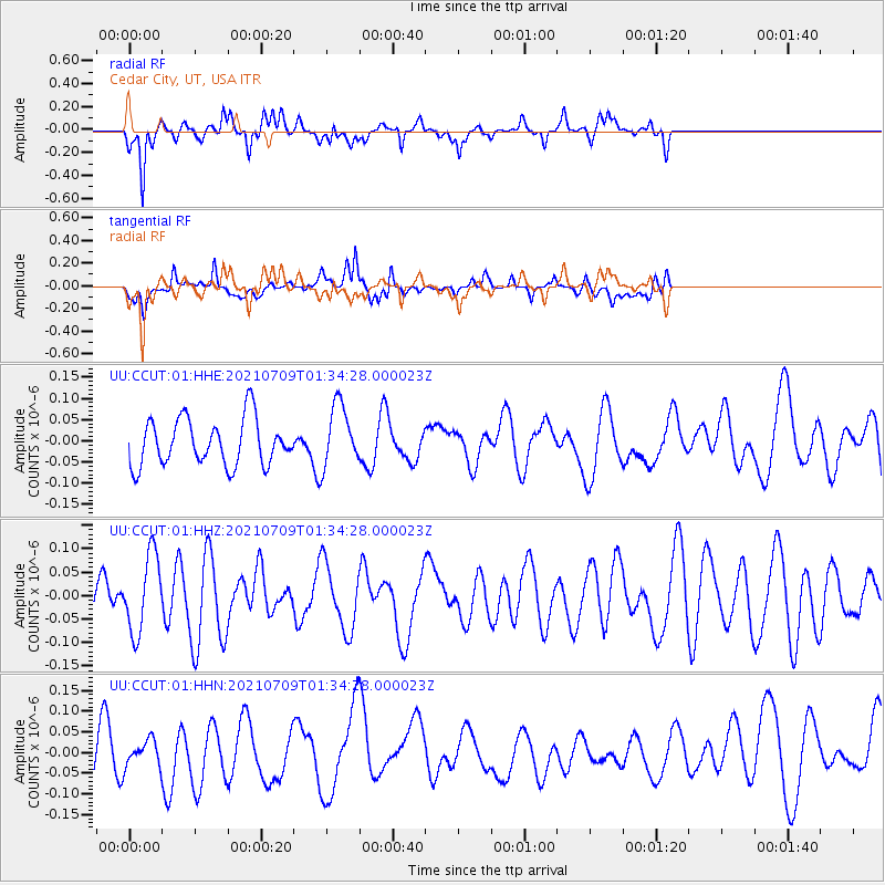
CCUT Cedar City, UT, USA - Earthquake Result Viewer
*The percent match for this event was below the threshold and hence no stack was calculated.
| Earthquake location: |
Pacific-Antarctic Ridge |
| Earthquake latitude/longitude: |
-56.2/-143.2 |
| Earthquake time(UTC): |
2021/07/09 (190) 01:21:29 GMT |
| Earthquake Depth: |
10 km |
| Earthquake Magnitude: |
5.5 Mww |
| Earthquake Catalog/Contributor: |
NEIC PDE/us |
|
| Network: |
UU University of Utah Regional Network |
| Station: |
CCUT Cedar City, UT, USA |
| Lat/Lon: |
37.55 N/113.36 W |
| Elevation: |
2127 m |
|
| Distance: |
96.8 deg |
| Az: |
23.483 deg |
| Baz: |
196.274 deg |
| Ray Param: |
$rayparam |
*The percent match for this event was below the threshold and hence was not used in the summary stack. |
|
| Radial Match: |
69.2413 % |
| Radial Bump: |
375 |
| Transverse Match: |
46.109806 % |
| Transverse Bump: |
400 |
| SOD ConfigId: |
25131211 |
| Insert Time: |
2021-08-05 21:35:24.470 +0000 |
| GWidth: |
2.5 |
| Max Bumps: |
400 |
| Tol: |
0.001 |
|
Signal To Noise
| Channel | StoN | STA | LTA |
| UU:CCUT:01:HHZ:20210709T01:34:28.000023Z | 1.5230772 | 8.266223E-8 | 5.427317E-8 |
| UU:CCUT:01:HHN:20210709T01:34:28.000023Z | 0.5529779 | 3.15524E-8 | 5.7059058E-8 |
| UU:CCUT:01:HHE:20210709T01:34:28.000023Z | 1.3625766 | 7.430481E-8 | 5.453257E-8 |
| Arrivals |
| Ps | |
| PpPs | |
| PsPs/PpSs | |


