You are here: Home > Network List > IU - Global Seismograph Network (GSN - IRIS/USGS) Stations List
> Station JOHN Johnston Island, USA > Earthquake Result Viewer
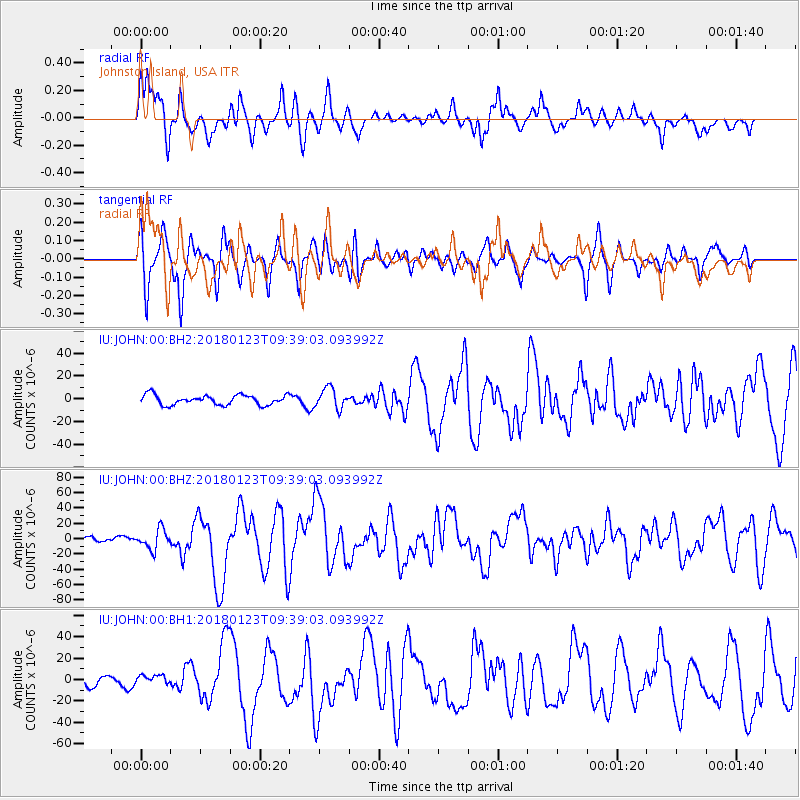
JOHN Johnston Island, USA - Earthquake Result Viewer
*The percent match for this event was below the threshold and hence no stack was calculated.
| Earthquake location: |
Gulf Of Alaska |
| Earthquake latitude/longitude: |
56.0/-149.1 |
| Earthquake time(UTC): |
2018/01/23 (023) 09:31:42 GMT |
| Earthquake Depth: |
25 km |
| Earthquake Magnitude: |
7.9 Mww |
| Earthquake Catalog/Contributor: |
NEIC PDE/us |
|
| Network: |
IU Global Seismograph Network (GSN - IRIS/USGS) |
| Station: |
JOHN Johnston Island, USA |
| Lat/Lon: |
16.73 N/169.53 W |
| Elevation: |
2.0 m |
|
| Distance: |
42.2 deg |
| Az: |
209.892 deg |
| Baz: |
16.968 deg |
| Ray Param: |
$rayparam |
*The percent match for this event was below the threshold and hence was not used in the summary stack. |
|
| Radial Match: |
77.59313 % |
| Radial Bump: |
400 |
| Transverse Match: |
82.51522 % |
| Transverse Bump: |
381 |
| SOD ConfigId: |
2546091 |
| Insert Time: |
2018-02-06 09:34:48.575 +0000 |
| GWidth: |
2.5 |
| Max Bumps: |
400 |
| Tol: |
0.001 |
|
Signal To Noise
| Channel | StoN | STA | LTA |
| IU:JOHN:00:BHZ:20180123T09:39:03.093992Z | 3.6449008 | 1.2892969E-5 | 3.5372618E-6 |
| IU:JOHN:00:BH1:20180123T09:39:03.093992Z | 1.1119125 | 4.108939E-6 | 3.6953793E-6 |
| IU:JOHN:00:BH2:20180123T09:39:03.093992Z | 2.047998 | 8.852789E-6 | 4.3226546E-6 |
| Arrivals |
| Ps | |
| PpPs | |
| PsPs/PpSs | |


