You are here: Home > Network List > IU - Global Seismograph Network (GSN - IRIS/USGS) Stations List
> Station PAB San Pablo, Spain > Earthquake Result Viewer
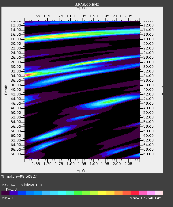
PAB San Pablo, Spain - Earthquake Result Viewer
| Earthquake location: |
Gulf Of Alaska |
| Earthquake latitude/longitude: |
56.0/-149.1 |
| Earthquake time(UTC): |
2018/01/23 (023) 09:31:42 GMT |
| Earthquake Depth: |
25 km |
| Earthquake Magnitude: |
7.9 Mww |
| Earthquake Catalog/Contributor: |
NEIC PDE/us |
|
| Network: |
IU Global Seismograph Network (GSN - IRIS/USGS) |
| Station: |
PAB San Pablo, Spain |
| Lat/Lon: |
39.54 N/4.35 W |
| Elevation: |
950 m |
|
| Distance: |
80.2 deg |
| Az: |
26.95 deg |
| Baz: |
340.799 deg |
| Ray Param: |
0.04843083 |
| Estimated Moho Depth: |
33.5 km |
| Estimated Crust Vp/Vs: |
1.60 |
| Assumed Crust Vp: |
6.276 km/s |
| Estimated Crust Vs: |
3.922 km/s |
| Estimated Crust Poisson's Ratio: |
0.18 |
|
| Radial Match: |
98.50927 % |
| Radial Bump: |
249 |
| Transverse Match: |
91.80646 % |
| Transverse Bump: |
400 |
| SOD ConfigId: |
2546091 |
| Insert Time: |
2018-02-06 09:34:57.718 +0000 |
| GWidth: |
2.5 |
| Max Bumps: |
400 |
| Tol: |
0.001 |
|

Signal To Noise
| Channel | StoN | STA | LTA |
| IU:PAB:00:BHZ:20180123T09:43:19.669004Z | 3.3459597 | 8.948297E-7 | 2.674359E-7 |
| IU:PAB:00:BH1:20180123T09:43:19.669004Z | 1.64983 | 2.9214888E-7 | 1.7707818E-7 |
| IU:PAB:00:BH2:20180123T09:43:19.669004Z | 0.959399 | 1.8898932E-7 | 1.9698722E-7 |
| Arrivals |
| Ps | 3.3 SECOND |
| PpPs | 13 SECOND |
| PsPs/PpSs | 17 SECOND |


