You are here: Home > Network List > IU - Global Seismograph Network (GSN - IRIS/USGS) Stations List
> Station PAYG Puerto Ayora, Galapagos Islands > Earthquake Result Viewer
PAYG Puerto Ayora, Galapagos Islands - Earthquake Result Viewer
| Earthquake location: |
Gulf Of Alaska |
| Earthquake latitude/longitude: |
56.0/-149.1 |
| Earthquake time(UTC): |
2018/01/23 (023) 09:31:42 GMT |
| Earthquake Depth: |
25 km |
| Earthquake Magnitude: |
7.9 Mww |
| Earthquake Catalog/Contributor: |
NEIC PDE/us |
|
| Network: |
IU Global Seismograph Network (GSN - IRIS/USGS) |
| Station: |
PAYG Puerto Ayora, Galapagos Islands |
| Lat/Lon: |
0.67 S/90.29 W |
| Elevation: |
270 m |
|
| Distance: |
73.7 deg |
| Az: |
116.987 deg |
| Baz: |
329.997 deg |
| Ray Param: |
0.05281571 |
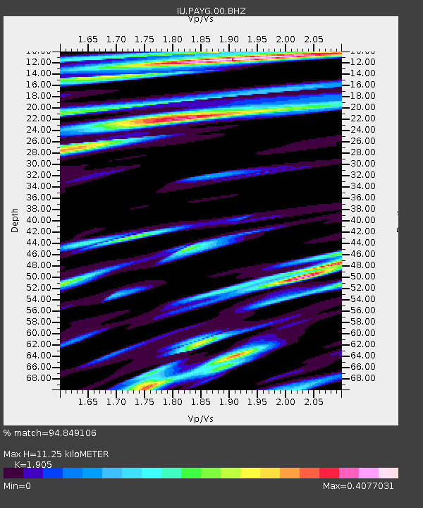
| Estimated Moho Depth: |
11.25 km |
| Estimated Crust Vp/Vs: |
1.90 |
| Assumed Crust Vp: |
4.802 km/s |
| Estimated Crust Vs: |
2.521 km/s |
| Estimated Crust Poisson's Ratio: |
0.31 |
|
| Radial Match: |
94.849106 % |
| Radial Bump: |
294 |
| Transverse Match: |
88.965385 % |
| Transverse Bump: |
400 |
| SOD ConfigId: |
2546091 |
| Insert Time: |
2018-02-06 09:34:58.122 +0000 |
| GWidth: |
2.5 |
| Max Bumps: |
400 |
| Tol: |
0.001 |
|
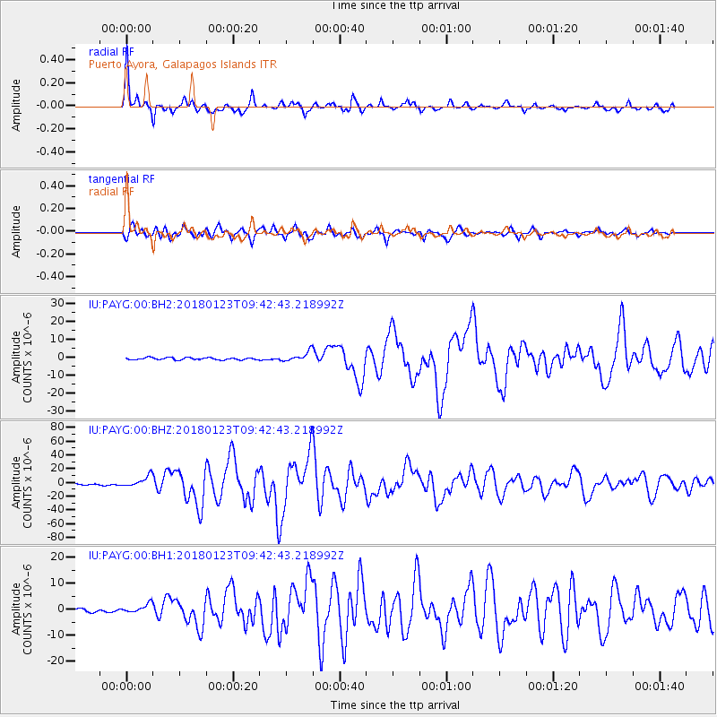
Signal To Noise
| Channel | StoN | STA | LTA |
| IU:PAYG:00:BHZ:20180123T09:42:43.218992Z | 10.084694 | 8.048523E-6 | 7.9809297E-7 |
| IU:PAYG:00:BH1:20180123T09:42:43.218992Z | 3.1257107 | 1.7196116E-6 | 5.501506E-7 |
| IU:PAYG:00:BH2:20180123T09:42:43.218992Z | 4.4471 | 2.7191757E-6 | 6.114492E-7 |
| Arrivals |
| Ps | 2.2 SECOND |
| PpPs | 6.7 SECOND |
| PsPs/PpSs | 8.8 SECOND |


