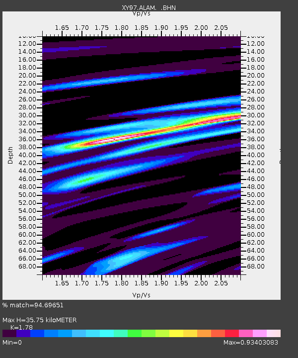
ALAM El Alamito - Earthquake Result Viewer

Earthquake location: Near East Coast Of Kamchatka
Earthquake latitude/longitude: 54.8/162.0
Earthquake time(UTC): 1997/12/05 (339) 11:26:54 GMT
Earthquake Depth: 33 km
Earthquake Magnitude: 6.3 MB, 7.6 MS, 7.9 UNKNOWN, 7.3 ME
Earthquake Catalog/Contributor: WHDF/NEIC
Network: XY Northern Baja Transect
Station: ALAM El Alamito
Lat/Lon: 30.99 N/115.57 W
Elevation: 2396 m
Distance: 61.1 deg
Az: 76.546 deg
Baz: 319.077 deg
Ray Param: 0.061052233
Estimated Moho Depth: 35.75 km
Estimated Crust Vp/Vs: 1.78
Assumed Crust Vp: 6.276 km/s
Estimated Crust Vs: 3.526 km/s
Estimated Crust Poisson's Ratio: 0.27
Radial Match: 94.69651 %
Radial Bump: 376
Transverse Match: 83.264244 %
Transverse Bump: 400
SOD ConfigId: 9875
Insert Time: 2010-03-09 10:49:43.529 +0000
GWidth: 2.5
Max Bumps: 400
Tol: 0.001

Signal To Noise

ChannelStoNSTALTA
XY:ALAM: :BHN:19971205T11:36:34.524011Z1.37396442.1642647E-71.575197E-7
XY:ALAM: :BHE:19971205T11:36:34.524011Z0.264940386.576557E-82.482278E-7
XY:ALAM: :BHZ:19971205T11:36:34.524011Z2.05447323.4609013E-71.6845688E-7
Arrivals
Ps4.6 SECOND
PpPs15 SECOND
PsPs/PpSs20 SECOND