You are here: Home > Network List > AK - Alaska Regional Network Stations List
> Station BAE Barry Arm East, AK, USA > Earthquake Result Viewer
BAE Barry Arm East, AK, USA - Earthquake Result Viewer
| Earthquake location: |
Mindoro, Philippines |
| Earthquake latitude/longitude: |
13.7/120.7 |
| Earthquake time(UTC): |
2021/07/23 (204) 20:48:57 GMT |
| Earthquake Depth: |
110 km |
| Earthquake Magnitude: |
6.7 mww |
| Earthquake Catalog/Contributor: |
NEIC PDE/us |
|
| Network: |
AK Alaska Regional Network |
| Station: |
BAE Barry Arm East, AK, USA |
| Lat/Lon: |
61.13 N/148.12 W |
| Elevation: |
578 m |
|
| Distance: |
78.7 deg |
| Az: |
29.658 deg |
| Baz: |
277.688 deg |
| Ray Param: |
0.049233425 |
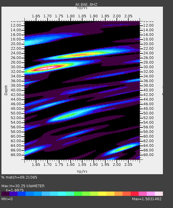
| Estimated Moho Depth: |
30.25 km |
| Estimated Crust Vp/Vs: |
1.70 |
| Assumed Crust Vp: |
6.566 km/s |
| Estimated Crust Vs: |
3.868 km/s |
| Estimated Crust Poisson's Ratio: |
0.23 |
|
| Radial Match: |
89.21065 % |
| Radial Bump: |
400 |
| Transverse Match: |
89.91311 % |
| Transverse Bump: |
400 |
| SOD ConfigId: |
25131211 |
| Insert Time: |
2021-08-06 20:49:37.325 +0000 |
| GWidth: |
2.5 |
| Max Bumps: |
400 |
| Tol: |
0.001 |
|

Signal To Noise
| Channel | StoN | STA | LTA |
| AK:BAE: :BHZ:20210723T21:00:16.328013Z | 22.458467 | 4.545259E-6 | 2.0238508E-7 |
| AK:BAE: :BHN:20210723T21:00:16.328013Z | 4.844641 | 7.9061215E-7 | 1.6319314E-7 |
| AK:BAE: :BHE:20210723T21:00:16.328013Z | 10.70255 | 1.7479005E-6 | 1.6331626E-7 |
| Arrivals |
| Ps | 3.3 SECOND |
| PpPs | 12 SECOND |
| PsPs/PpSs | 15 SECOND |


