You are here: Home > Network List > AK - Alaska Regional Network Stations List
> Station CHUM Lake Minchumina Broadband > Earthquake Result Viewer
CHUM Lake Minchumina Broadband - Earthquake Result Viewer
| Earthquake location: |
Mindoro, Philippines |
| Earthquake latitude/longitude: |
13.7/120.7 |
| Earthquake time(UTC): |
2021/07/23 (204) 20:48:57 GMT |
| Earthquake Depth: |
110 km |
| Earthquake Magnitude: |
6.7 mww |
| Earthquake Catalog/Contributor: |
NEIC PDE/us |
|
| Network: |
AK Alaska Regional Network |
| Station: |
CHUM Lake Minchumina Broadband |
| Lat/Lon: |
63.88 N/152.31 W |
| Elevation: |
58 m |
|
| Distance: |
76.5 deg |
| Az: |
27.038 deg |
| Baz: |
273.41 deg |
| Ray Param: |
0.050718192 |
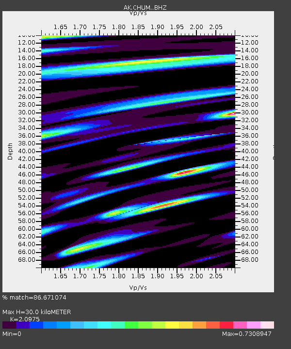
| Estimated Moho Depth: |
30.0 km |
| Estimated Crust Vp/Vs: |
2.10 |
| Assumed Crust Vp: |
6.566 km/s |
| Estimated Crust Vs: |
3.13 km/s |
| Estimated Crust Poisson's Ratio: |
0.35 |
|
| Radial Match: |
86.671074 % |
| Radial Bump: |
400 |
| Transverse Match: |
72.95123 % |
| Transverse Bump: |
400 |
| SOD ConfigId: |
25131211 |
| Insert Time: |
2021-08-06 20:50:07.083 +0000 |
| GWidth: |
2.5 |
| Max Bumps: |
400 |
| Tol: |
0.001 |
|

Signal To Noise
| Channel | StoN | STA | LTA |
| AK:CHUM: :BHZ:20210723T21:00:04.128001Z | 45.122456 | 3.9064685E-6 | 8.6574815E-8 |
| AK:CHUM: :BHN:20210723T21:00:04.128001Z | 1.5561469 | 2.1491962E-7 | 1.3811011E-7 |
| AK:CHUM: :BHE:20210723T21:00:04.128001Z | 8.313685 | 8.2380535E-7 | 9.909027E-8 |
| Arrivals |
| Ps | 5.2 SECOND |
| PpPs | 14 SECOND |
| PsPs/PpSs | 19 SECOND |


