You are here: Home > Network List > AK - Alaska Regional Network Stations List
> Station FID Fidalgo > Earthquake Result Viewer
FID Fidalgo - Earthquake Result Viewer
| Earthquake location: |
Mindoro, Philippines |
| Earthquake latitude/longitude: |
13.7/120.7 |
| Earthquake time(UTC): |
2021/07/23 (204) 20:48:57 GMT |
| Earthquake Depth: |
110 km |
| Earthquake Magnitude: |
6.7 mww |
| Earthquake Catalog/Contributor: |
NEIC PDE/us |
|
| Network: |
AK Alaska Regional Network |
| Station: |
FID Fidalgo |
| Lat/Lon: |
60.73 N/146.60 W |
| Elevation: |
488 m |
|
| Distance: |
79.5 deg |
| Az: |
29.956 deg |
| Baz: |
279.077 deg |
| Ray Param: |
0.04869332 |
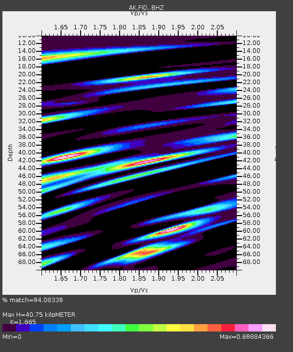
| Estimated Moho Depth: |
40.75 km |
| Estimated Crust Vp/Vs: |
1.66 |
| Assumed Crust Vp: |
6.566 km/s |
| Estimated Crust Vs: |
3.944 km/s |
| Estimated Crust Poisson's Ratio: |
0.22 |
|
| Radial Match: |
94.08339 % |
| Radial Bump: |
400 |
| Transverse Match: |
81.158035 % |
| Transverse Bump: |
400 |
| SOD ConfigId: |
25131211 |
| Insert Time: |
2021-08-06 20:50:45.605 +0000 |
| GWidth: |
2.5 |
| Max Bumps: |
400 |
| Tol: |
0.001 |
|

Signal To Noise
| Channel | StoN | STA | LTA |
| AK:FID: :BHZ:20210723T21:00:20.648021Z | 20.387129 | 4.575054E-6 | 2.2440894E-7 |
| AK:FID: :BHN:20210723T21:00:20.648021Z | 2.404379 | 6.8276995E-7 | 2.8396937E-7 |
| AK:FID: :BHE:20210723T21:00:20.648021Z | 9.42802 | 1.843614E-6 | 1.9554625E-7 |
| Arrivals |
| Ps | 4.3 SECOND |
| PpPs | 16 SECOND |
| PsPs/PpSs | 20 SECOND |


