You are here: Home > Network List > AK - Alaska Regional Network Stations List
> Station I27K Kandik River, AK, USA > Earthquake Result Viewer
I27K Kandik River, AK, USA - Earthquake Result Viewer
| Earthquake location: |
Mindoro, Philippines |
| Earthquake latitude/longitude: |
13.7/120.7 |
| Earthquake time(UTC): |
2021/07/23 (204) 20:48:57 GMT |
| Earthquake Depth: |
110 km |
| Earthquake Magnitude: |
6.7 mww |
| Earthquake Catalog/Contributor: |
NEIC PDE/us |
|
| Network: |
AK Alaska Regional Network |
| Station: |
I27K Kandik River, AK, USA |
| Lat/Lon: |
65.60 N/141.62 W |
| Elevation: |
874 m |
|
| Distance: |
80.8 deg |
| Az: |
24.649 deg |
| Baz: |
282.609 deg |
| Ray Param: |
0.047809217 |
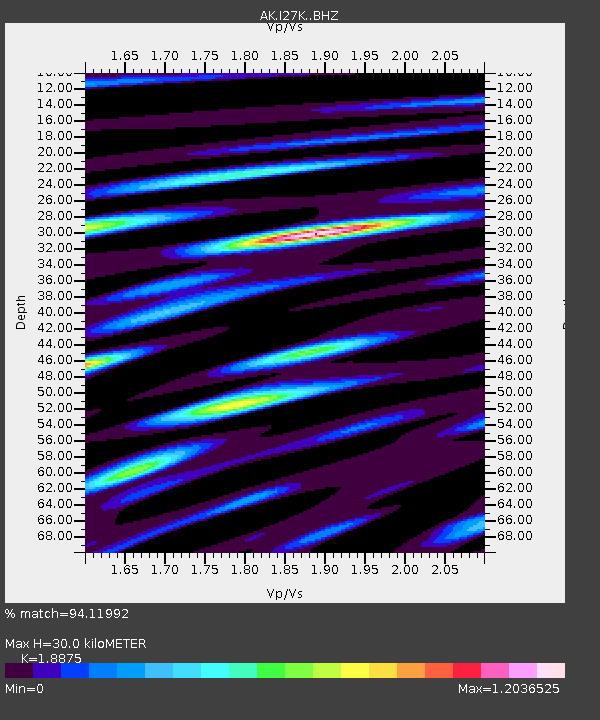
| Estimated Moho Depth: |
30.0 km |
| Estimated Crust Vp/Vs: |
1.89 |
| Assumed Crust Vp: |
6.566 km/s |
| Estimated Crust Vs: |
3.479 km/s |
| Estimated Crust Poisson's Ratio: |
0.30 |
|
| Radial Match: |
94.11992 % |
| Radial Bump: |
400 |
| Transverse Match: |
81.78801 % |
| Transverse Bump: |
400 |
| SOD ConfigId: |
25131211 |
| Insert Time: |
2021-08-06 20:51:30.852 +0000 |
| GWidth: |
2.5 |
| Max Bumps: |
400 |
| Tol: |
0.001 |
|

Signal To Noise
| Channel | StoN | STA | LTA |
| AK:I27K: :BHZ:20210723T21:00:27.620005Z | 80.24728 | 3.7911416E-6 | 4.7243244E-8 |
| AK:I27K: :BHN:20210723T21:00:27.620005Z | 2.1066809 | 1.2163306E-7 | 5.7736823E-8 |
| AK:I27K: :BHE:20210723T21:00:27.620005Z | 15.399526 | 1.1424047E-6 | 7.4184406E-8 |
| Arrivals |
| Ps | 4.2 SECOND |
| PpPs | 13 SECOND |
| PsPs/PpSs | 17 SECOND |


