You are here: Home > Network List > AK - Alaska Regional Network Stations List
> Station O20K Slope Mountain, AK, USA > Earthquake Result Viewer
O20K Slope Mountain, AK, USA - Earthquake Result Viewer
| Earthquake location: |
Mindoro, Philippines |
| Earthquake latitude/longitude: |
13.7/120.7 |
| Earthquake time(UTC): |
2021/07/23 (204) 20:48:57 GMT |
| Earthquake Depth: |
110 km |
| Earthquake Magnitude: |
6.7 mww |
| Earthquake Catalog/Contributor: |
NEIC PDE/us |
|
| Network: |
AK Alaska Regional Network |
| Station: |
O20K Slope Mountain, AK, USA |
| Lat/Lon: |
60.08 N/152.62 W |
| Elevation: |
915 m |
|
| Distance: |
76.6 deg |
| Az: |
30.963 deg |
| Baz: |
274.053 deg |
| Ray Param: |
0.050647326 |
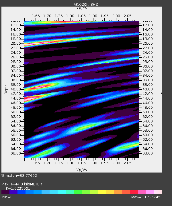
| Estimated Moho Depth: |
44.0 km |
| Estimated Crust Vp/Vs: |
1.62 |
| Assumed Crust Vp: |
6.566 km/s |
| Estimated Crust Vs: |
4.047 km/s |
| Estimated Crust Poisson's Ratio: |
0.19 |
|
| Radial Match: |
83.77602 % |
| Radial Bump: |
400 |
| Transverse Match: |
75.83342 % |
| Transverse Bump: |
400 |
| SOD ConfigId: |
25131211 |
| Insert Time: |
2021-08-06 20:52:39.196 +0000 |
| GWidth: |
2.5 |
| Max Bumps: |
400 |
| Tol: |
0.001 |
|

Signal To Noise
| Channel | StoN | STA | LTA |
| AK:O20K: :BHZ:20210723T21:00:04.700022Z | 10.82388 | 3.8935714E-6 | 3.5972047E-7 |
| AK:O20K: :BHN:20210723T21:00:04.700022Z | 3.1952198 | 1.3900797E-6 | 4.3504977E-7 |
| AK:O20K: :BHE:20210723T21:00:04.700022Z | 4.0510993 | 1.3480214E-6 | 3.327545E-7 |
| Arrivals |
| Ps | 4.3 SECOND |
| PpPs | 17 SECOND |
| PsPs/PpSs | 21 SECOND |


