You are here: Home > Network List > AK - Alaska Regional Network Stations List
> Station PNL Peninsula > Earthquake Result Viewer
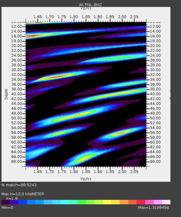
PNL Peninsula - Earthquake Result Viewer
| Earthquake location: |
Mindoro, Philippines |
| Earthquake latitude/longitude: |
13.7/120.7 |
| Earthquake time(UTC): |
2021/07/23 (204) 20:48:57 GMT |
| Earthquake Depth: |
110 km |
| Earthquake Magnitude: |
6.7 mww |
| Earthquake Catalog/Contributor: |
NEIC PDE/us |
|
| Network: |
AK Alaska Regional Network |
| Station: |
PNL Peninsula |
| Lat/Lon: |
59.67 N/139.40 W |
| Elevation: |
596 m |
|
| Distance: |
83.2 deg |
| Az: |
30.237 deg |
| Baz: |
285.357 deg |
| Ray Param: |
0.04611287 |
| Estimated Moho Depth: |
10.0 km |
| Estimated Crust Vp/Vs: |
1.60 |
| Assumed Crust Vp: |
6.183 km/s |
| Estimated Crust Vs: |
3.864 km/s |
| Estimated Crust Poisson's Ratio: |
0.18 |
|
| Radial Match: |
88.5243 % |
| Radial Bump: |
400 |
| Transverse Match: |
85.82779 % |
| Transverse Bump: |
400 |
| SOD ConfigId: |
25131211 |
| Insert Time: |
2021-08-06 20:52:46.147 +0000 |
| GWidth: |
2.5 |
| Max Bumps: |
400 |
| Tol: |
0.001 |
|

Signal To Noise
| Channel | StoN | STA | LTA |
| AK:PNL: :BHZ:20210723T21:00:40.287974Z | 12.132602 | 3.0737156E-6 | 2.5334347E-7 |
| AK:PNL: :BHN:20210723T21:00:40.287974Z | 1.741344 | 5.4248375E-7 | 3.1153164E-7 |
| AK:PNL: :BHE:20210723T21:00:40.287974Z | 2.5386772 | 6.8832577E-7 | 2.7113558E-7 |
| Arrivals |
| Ps | 1.0 SECOND |
| PpPs | 4.1 SECOND |
| PsPs/PpSs | 5.1 SECOND |


