You are here: Home > Network List > XY97 - Northern Baja Transect Stations List
> Station LACB Las Cabras > Earthquake Result Viewer
LACB Las Cabras - Earthquake Result Viewer
| Earthquake location: |
Northern Peru |
| Earthquake latitude/longitude: |
-4.4/-76.7 |
| Earthquake time(UTC): |
1997/10/28 (301) 06:15:17 GMT |
| Earthquake Depth: |
112 km |
| Earthquake Magnitude: |
6.6 MB, 6.3 MS, 7.2 UNKNOWN, 6.6 ME |
| Earthquake Catalog/Contributor: |
WHDF/NEIC |
|
| Network: |
XY Northern Baja Transect |
| Station: |
LACB Las Cabras |
| Lat/Lon: |
30.96 N/115.80 W |
| Elevation: |
672 m |
|
| Distance: |
51.3 deg |
| Az: |
315.984 deg |
| Baz: |
126.238 deg |
| Ray Param: |
0.06716448 |
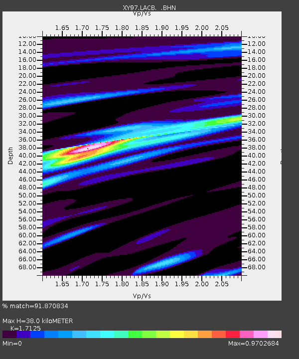
| Estimated Moho Depth: |
38.0 km |
| Estimated Crust Vp/Vs: |
1.71 |
| Assumed Crust Vp: |
6.276 km/s |
| Estimated Crust Vs: |
3.665 km/s |
| Estimated Crust Poisson's Ratio: |
0.24 |
|
| Radial Match: |
91.870834 % |
| Radial Bump: |
297 |
| Transverse Match: |
80.485504 % |
| Transverse Bump: |
400 |
| SOD ConfigId: |
6273 |
| Insert Time: |
2010-03-09 10:50:16.595 +0000 |
| GWidth: |
2.5 |
| Max Bumps: |
400 |
| Tol: |
0.001 |
|

Signal To Noise
| Channel | StoN | STA | LTA |
| XY:LACB: :BHN:19971028T06:23:39.073987Z | 6.8628297 | 3.120396E-7 | 4.5468067E-8 |
| XY:LACB: :BHE:19971028T06:23:39.073987Z | 7.9233336 | 3.301495E-7 | 4.1668006E-8 |
| XY:LACB: :BHZ:19971028T06:23:39.073987Z | 13.621977 | 1.0081716E-6 | 7.4010664E-8 |
| Arrivals |
| Ps | 4.6 SECOND |
| PpPs | 16 SECOND |
| PsPs/PpSs | 20 SECOND |


