You are here: Home > Network List > AK - Alaska Regional Network Stations List
> Station YAH Yahtse, AK, USA > Earthquake Result Viewer
YAH Yahtse, AK, USA - Earthquake Result Viewer
| Earthquake location: |
Mindoro, Philippines |
| Earthquake latitude/longitude: |
13.7/120.7 |
| Earthquake time(UTC): |
2021/07/23 (204) 20:48:57 GMT |
| Earthquake Depth: |
110 km |
| Earthquake Magnitude: |
6.7 mww |
| Earthquake Catalog/Contributor: |
NEIC PDE/us |
|
| Network: |
AK Alaska Regional Network |
| Station: |
YAH Yahtse, AK, USA |
| Lat/Lon: |
60.36 N/141.75 W |
| Elevation: |
2125 m |
|
| Distance: |
81.9 deg |
| Az: |
29.854 deg |
| Baz: |
283.274 deg |
| Ray Param: |
0.047027294 |
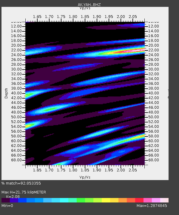
| Estimated Moho Depth: |
21.75 km |
| Estimated Crust Vp/Vs: |
2.08 |
| Assumed Crust Vp: |
6.566 km/s |
| Estimated Crust Vs: |
3.157 km/s |
| Estimated Crust Poisson's Ratio: |
0.35 |
|
| Radial Match: |
92.853355 % |
| Radial Bump: |
400 |
| Transverse Match: |
89.478485 % |
| Transverse Bump: |
400 |
| SOD ConfigId: |
25131211 |
| Insert Time: |
2021-08-06 20:53:57.588 +0000 |
| GWidth: |
2.5 |
| Max Bumps: |
400 |
| Tol: |
0.001 |
|

Signal To Noise
| Channel | StoN | STA | LTA |
| AK:YAH: :BHZ:20210723T21:00:33.508006Z | 8.561622 | 1.9816625E-6 | 2.3145877E-7 |
| AK:YAH: :BHN:20210723T21:00:33.508006Z | 3.5676332 | 5.6859443E-7 | 1.5937582E-7 |
| AK:YAH: :BHE:20210723T21:00:33.508006Z | 2.929 | 8.3257265E-7 | 2.842515E-7 |
| Arrivals |
| Ps | 3.7 SECOND |
| PpPs | 10.0 SECOND |
| PsPs/PpSs | 14 SECOND |


